Laboule
show This article may be expanded with text translated from the corresponding article in French. (December 2008) Click [show] for important translation instructions. |
Laboule | |
|---|---|
Commune | |
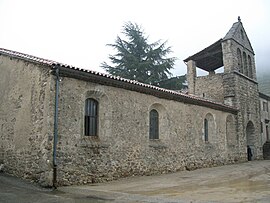 The church in Laboule | |
show Location of Laboule | |
 Laboule | |
| Coordinates: 44°35′19″N 4°10′00″E / 44.5886°N 4.1667°ECoordinates: 44°35′19″N 4°10′00″E / 44.5886°N 4.1667°E | |
| Country | France |
| Region | Auvergne-Rhône-Alpes |
| Department | Ardèche |
| Arrondissement | Largentière |
| Canton | Les Cévennes ardéchoises |
| Intercommunality | Pays Beaume Drobie |
| Government | |
| • Mayor (2008–2014) | Denise Ferrari |
| Area 1 | 17.45 km2 (6.74 sq mi) |
| Population (Jan. 2018)[1] | 141 |
| • Density | 8.1/km2 (21/sq mi) |
| Time zone | UTC+01:00 (CET) |
| • Summer (DST) | UTC+02:00 (CEST) |
| INSEE/Postal code | 07118 /07110 |
| Elevation | 393–1,410 m (1,289–4,626 ft) (avg. 550 m or 1,800 ft) |
| 1 French Land Register data, which excludes lakes, ponds, glaciers > 1 km2 (0.386 sq mi or 247 acres) and river estuaries. | |


Laboule is a commune in the Ardèche department in southern France.
Population[]
|
|
See also[]
References[]
- ^ "Populations légales 2018". INSEE. 28 December 2020.
| Wikimedia Commons has media related to Laboule. |
| Authority control |
|
|---|
This Ardèche geographical article is a stub. You can help Wikipedia by . |
Categories:
- Communes of Ardèche
- Ardèche geography stubs