Lahonce
Lahonce
Lehuntze | |
|---|---|
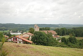 A general view of Lahonce | |
show Location of Lahonce | |
 Lahonce | |
| Coordinates: 43°29′00″N 1°23′24″W / 43.4833°N 1.39°WCoordinates: 43°29′00″N 1°23′24″W / 43.4833°N 1.39°W | |
| Country | France |
| Region | Nouvelle-Aquitaine |
| Department | Pyrénées-Atlantiques |
| Arrondissement | Bayonne |
| Canton | Nive-Adour |
| Intercommunality | CA Pays Basque |
| Government | |
| • Mayor (2020–2026) | David Hugla |
| Area 1 | 9.47 km2 (3.66 sq mi) |
| Population (Jan. 2018)[1] | 2,462 |
| • Density | 260/km2 (670/sq mi) |
| Time zone | UTC+01:00 (CET) |
| • Summer (DST) | UTC+02:00 (CEST) |
| INSEE/Postal code | 64304 /64990 |
| Elevation | 0–96 m (0–315 ft) (avg. 43 m or 141 ft) |
| 1 French Land Register data, which excludes lakes, ponds, glaciers > 1 km2 (0.386 sq mi or 247 acres) and river estuaries. | |


show This article may be expanded with text translated from the corresponding article in French. (December 2008) Click [show] for important translation instructions. |
Lahonce (French pronunciation: [la.ɔ̃s]; Basque: Lehuntze) is a village in the traditional Basque province of Labourd, now a commune in the Pyrénées-Atlantiques department in south-western France.
See also[]
References[]
- ^ "Populations légales 2018". INSEE. 28 December 2020.
External links[]
| Wikimedia Commons has media related to Lahonce. |
| show in Labourd (Lapurdi) |
|---|

This Pyrénées-Atlantiques geographical article is a stub. You can help Wikipedia by . |
Categories:
- Labourd
- Communes of Pyrénées-Atlantiques
- Pyrénées-Atlantiques geography stubs