Lantabat
Lantabat
Landibarre | |
|---|---|
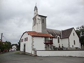 The church of Lantabat | |
show Location of Lantabat | |
 Lantabat | |
| Coordinates: 43°15′03″N 1°07′24″W / 43.2508°N 1.1233°WCoordinates: 43°15′03″N 1°07′24″W / 43.2508°N 1.1233°W | |
| Country | France |
| Region | Nouvelle-Aquitaine |
| Department | Pyrénées-Atlantiques |
| Arrondissement | Bayonne |
| Canton | Pays de Bidache, Amikuze et Ostibarre |
| Intercommunality | CA Pays Basque |
| Government | |
| • Mayor (2008–2014) | Yves Ondars |
| Area 1 | 28.86 km2 (11.14 sq mi) |
| Population (Jan. 2018)[1] | 279 |
| • Density | 9.7/km2 (25/sq mi) |
| Time zone | UTC+01:00 (CET) |
| • Summer (DST) | UTC+02:00 (CEST) |
| INSEE/Postal code | 64313 /64640 |
| Elevation | 91–577 m (299–1,893 ft) (avg. 268 m or 879 ft) |
| 1 French Land Register data, which excludes lakes, ponds, glaciers > 1 km2 (0.386 sq mi or 247 acres) and river estuaries. | |


show This article may be expanded with text translated from the corresponding article in French. (December 2008) Click [show] for important translation instructions. |
Lantabat (Basque: Landibarre) is a commune in the Pyrénées-Atlantiques department in south-western France.
It is located in the former province of Lower Navarre.
See also[]
References[]
- ^ "Populations légales 2018". INSEE. 28 December 2020.
External links[]
| Wikimedia Commons has media related to Lantabat. |
- LANDIBARRE in the Bernardo Estornés Lasa - Auñamendi Encyclopedia (Euskomedia Fundazioa) (in Spanish)
This Pyrénées-Atlantiques geographical article is a stub. You can help Wikipedia by . |
Categories:
- Communes of Pyrénées-Atlantiques
- Lower Navarre
- Pyrénées-Atlantiques geography stubs