Le Cheylard
show This article may be expanded with text translated from the corresponding article in French. (December 2008) Click [show] for important translation instructions. |
Le Cheylard | |
|---|---|
Commune | |
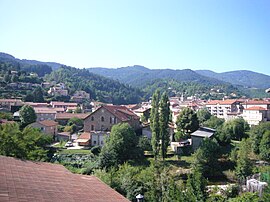 A general view of Le Cheylard | |
 Coat of arms | |
show Location of Le Cheylard | |
 Le Cheylard | |
| Coordinates: 44°54′22″N 4°25′23″E / 44.9061°N 4.4231°ECoordinates: 44°54′22″N 4°25′23″E / 44.9061°N 4.4231°E | |
| Country | France |
| Region | Auvergne-Rhône-Alpes |
| Department | Ardèche |
| Arrondissement | Tournon-sur-Rhône |
| Canton | Haut-Eyrieux |
| Government | |
| • Mayor (2020–2026) | Jacques Chabal[1] |
| Area 1 | 13.45 km2 (5.19 sq mi) |
| Population (Jan. 2018)[2] | 2,914 |
| • Density | 220/km2 (560/sq mi) |
| Time zone | UTC+01:00 (CET) |
| • Summer (DST) | UTC+02:00 (CEST) |
| INSEE/Postal code | 07064 /07160 |
| Elevation | 404–927 m (1,325–3,041 ft) (avg. 430 m or 1,410 ft) |
| 1 French Land Register data, which excludes lakes, ponds, glaciers > 1 km2 (0.386 sq mi or 247 acres) and river estuaries. | |


Le Cheylard (French pronunciation: [lə ʃelaʁ]; Occitan: Lo Chailar) is a commune in the Ardèche department in southern France.
Population[]
|
|
See also[]
References[]
- ^ "Répertoire national des élus: les maires". data.gouv.fr, Plateforme ouverte des données publiques françaises (in French). 2 December 2020.
- ^ "Populations légales 2018". INSEE. 28 December 2020.
External links[]
| Wikimedia Commons has media related to Le Cheylard. |
| show Authority control |
|---|
This Ardèche geographical article is a stub. You can help Wikipedia by . |
Categories:
- Communes of Ardèche
- Ardèche geography stubs