Le Puley
Le Puley | |
|---|---|
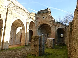 The Priory | |
 Coat of arms | |
show Location of Le Puley | |
 Le Puley | |
| Coordinates: 46°40′45″N 4°33′52″E / 46.6792°N 4.5644°ECoordinates: 46°40′45″N 4°33′52″E / 46.6792°N 4.5644°E | |
| Country | France |
| Region | Bourgogne-Franche-Comté |
| Department | Saône-et-Loire |
| Arrondissement | Chalon-sur-Saône |
| Canton | Blanzy |
| Area 1 | 5.3 km2 (2.0 sq mi) |
| Population (Jan. 2018)[1] | 92 |
| • Density | 17/km2 (45/sq mi) |
| Time zone | UTC+01:00 (CET) |
| • Summer (DST) | UTC+02:00 (CEST) |
| INSEE/Postal code | 71363 /71460 |
| Elevation | 249–421 m (817–1,381 ft) (avg. 260 m or 850 ft) |
| 1 French Land Register data, which excludes lakes, ponds, glaciers > 1 km2 (0.386 sq mi or 247 acres) and river estuaries. | |


Le Puley is a commune in the Saône-et-Loire department in the region of Bourgogne-Franche-Comté in eastern France.
Geography[]
The main roads are connecting the village to Germagny and Genouilly to the south and Saint-Micaud to the north.
Main sights[]
The romanesque priory "Saint Christophe" (12th century), protected in 1973 by the French National Heritage as a Monument historique.[2] The belltower collapsed on the building in 1877, causing major damages.
See also[]
- Guillaume des Autels who used to own a château named "des Hôtels" in le Puley.
- Communes of the Saône-et-Loire department
References[]
- ^ "Populations légales 2018". INSEE. 28 December 2020.
- ^ Base Mérimée: Monument historique registration number PA00113395, Ministère français de la Culture. (in French)
| Wikimedia Commons has media related to Le Puley. |
This Saône-et-Loire geographical article is a stub. You can help Wikipedia by . |
Categories:
- Communes of Saône-et-Loire
- Saône-et-Loire geography stubs