Monpezat
show This article may be expanded with text translated from the corresponding article in French. (December 2008) Click [show] for important translation instructions. |
Monpezat | |
|---|---|
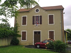 The town hall of Monpezat | |
show Location of Monpezat | |
 Monpezat | |
| Coordinates: 43°30′11″N 0°03′59″W / 43.5031°N 0.0664°WCoordinates: 43°30′11″N 0°03′59″W / 43.5031°N 0.0664°W | |
| Country | France |
| Region | Nouvelle-Aquitaine |
| Department | Pyrénées-Atlantiques |
| Arrondissement | Pau |
| Canton | Terres des Luys et Coteaux du Vic-Bilh |
| Government | |
| • Mayor (2020–2026) | Annick Carpentier Champroux[1] |
| Area 1 | 3 km2 (1 sq mi) |
| Population (Jan. 2018)[2] | 85 |
| • Density | 28/km2 (73/sq mi) |
| Time zone | UTC+01:00 (CET) |
| • Summer (DST) | UTC+02:00 (CEST) |
| INSEE/Postal code | 64394 /64350 |
| Elevation | 168–262 m (551–860 ft) (avg. 225 m or 738 ft) |
| 1 French Land Register data, which excludes lakes, ponds, glaciers > 1 km2 (0.386 sq mi or 247 acres) and river estuaries. | |


Monpezat is a commune in the Pyrénées-Atlantiques department in south-western France.
The Labésiau brook crosses the commune, on its way to the River Gabas.
See also[]
- French wine
- Communes of the Pyrénées-Atlantiques department
- Montpezat
- House of Laborde de Monpezat
References[]
- ^ "Répertoire national des élus: les maires". data.gouv.fr, Plateforme ouverte des données publiques françaises (in French). 2 December 2020. Retrieved 7 December 2020.
- ^ "Populations légales 2018". INSEE. 28 December 2020.
External links[]
| Wikimedia Commons has media related to Monpezat. |
This Pyrénées-Atlantiques geographical article is a stub. You can help Wikipedia by . |
Categories:
- Communes of Pyrénées-Atlantiques
- Pyrénées-Atlantiques geography stubs