Montpezat-sous-Bauzon
show This article may be expanded with text translated from the corresponding article in French. (December 2008) Click [show] for important translation instructions. |
Montpezat-sous-Bauzon | |
|---|---|
Commune | |
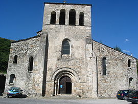 The church of Our Lady of Prévenchère, in Montpezat-sous-Bauzon | |
show Location of Montpezat-sous-Bauzon | |
 Montpezat-sous-Bauzon | |
| Coordinates: 44°42′47″N 4°12′26″E / 44.7131°N 4.2072°ECoordinates: 44°42′47″N 4°12′26″E / 44.7131°N 4.2072°E | |
| Country | France |
| Region | Auvergne-Rhône-Alpes |
| Department | Ardèche |
| Arrondissement | Largentière |
| Canton | Haute-Ardèche |
| Intercommunality | Ardèche des Sources et Volcans |
| Government | |
| • Mayor (2020–2026) | Marie-France Fabreges[1] |
| Area 1 | 27.23 km2 (10.51 sq mi) |
| Population (Jan. 2018)[2] | 739 |
| • Density | 27/km2 (70/sq mi) |
| Time zone | UTC+01:00 (CET) |
| • Summer (DST) | UTC+02:00 (CEST) |
| INSEE/Postal code | 07161 /07560 |
| Elevation | 430–1,464 m (1,411–4,803 ft) (avg. 550 m or 1,800 ft) |
| 1 French Land Register data, which excludes lakes, ponds, glaciers > 1 km2 (0.386 sq mi or 247 acres) and river estuaries. | |


Montpezat-sous-Bauzon is a commune in the Ardèche department in southern France.
Population[]
| Year | Pop. | ±% |
|---|---|---|
| 1962 | 566 | — |
| 1968 | 693 | +22.4% |
| 1975 | 676 | −2.5% |
| 1982 | 649 | −4.0% |
| 1990 | 698 | +7.6% |
| 1999 | 634 | −9.2% |
| 2008 | 780 | +23.0% |
See also[]
References[]
- ^ "Répertoire national des élus: les maires". data.gouv.fr, Plateforme ouverte des données publiques françaises (in French). 2 December 2020. Retrieved 7 December 2020.
- ^ "Populations légales 2018". INSEE. 28 December 2020.
| Wikimedia Commons has media related to Montpezat-sous-Bauzon. |
This Ardèche geographical article is a stub. You can help Wikipedia by . |
Categories:
- Communes of Ardèche
- Ardèche geography stubs