National Register of Historic Places listings in Bartow County, Georgia
This is a list of properties and districts in Bartow County, Georgia that are listed on the National Register of Historic Places (NRHP).
- This National Park Service list is complete through NPS recent listings posted January 28, 2022.[1]

Current listings[]
| [2] | Name on the Register | Image | Date listed[3] | Location | City or town | Description |
|---|---|---|---|---|---|---|
| 1 |  |
December 4, 1987 (#87002043) |
Roughly Main St. bounded by King & Elm Sts., & city limits on S & W 34°22′03″N 84°56′03″W / 34.3675°N 84.934167°W | Adairsville | ||
| 2 |  |
October 21, 2005 (#05001172) |
Roughly bounded by Sugar Valley Rd., Cassville Rd. and Pettit Creek, Wingfoot Trail and Litchfield St. 34°10′44″N 84°49′09″W / 34.178889°N 84.819167°W | Cartersville | ||
| 3 | Bartow County Courthouse |  |
September 18, 1980 (#80000971) |
Courthouse Sq. 34°09′57″N 84°47′52″W / 34.16592°N 84.79775°W | Cartersville | |
| 4 |  |
January 30, 1998 (#98000030) |
222 Grassdale Rd. 34°12′16″N 84°49′12″W / 34.20454°N 84.8201°W | Cartersville | ||
| 5 |  |
November 12, 2014 (#14000904) |
Roughly bounded by Church, Gilmer, Leake & Noble Sts. 34°09′55″N 84°47′49″W / 34.165245°N 84.796881°W | Cartersville | ||
| 6 | Cassville Post Office | 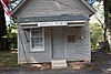 |
August 31, 1992 (#92001129) |
1813 Cassville Rd. (Old Dixie Hwy.) 34°14′58″N 84°51′10″W / 34.249444°N 84.852778°W | Cassville | |
| 7 | Etowah Mounds | 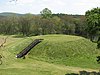 |
October 15, 1966 (#66000272) |
N bank of Etowah River 34°07′33″N 84°48′29″W / 34.125833°N 84.808056°W | Cartersville | A National Historic Landmark and a Georgia state historic site |
| 8 | June 30, 1975 (#75000573) |
Address Restricted | Cartersville | |||
| 9 |  |
January 31, 1979 (#79000697) |
N of Cartersville off U.S. 411 34°12′23″N 84°47′54″W / ���34.20628°N 84.79828°W | Cartersville | No longer there according to satellite view | |
| 10 | First Presbyterian Church |  |
August 29, 1991 (#91001157) |
183 W. Main St. 34°09′51″N 84°47′59″W / 34.164167°N 84.799722°W | Cartersville | |
| 11 | 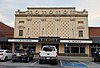 |
June 28, 1984 (#84000893) |
2 Wall St. 34°09′59″N 84°47′44″W / 34.166389°N 84.795556°W | Cartersville | ||
| 12 | Corra White Harris House, Study, and Chapel | July 25, 1997 (#97000249) |
659 Mt. Pleasant Rd., NE. 34°22′15″N 84°45′39″W / 34.37093°N 84.76093°W | Rydal | ||
| 13 | Sam Jones Memorial United Methodist Church |  |
September 5, 1985 (#85001972) |
100 W. Church St. 34°09′59″N 84°47′52″W / 34.16636°N 84.79774°W | Cartersville | |
| 14 |  |
July 2, 1987 (#87001103) |
2361 Frank Harris Pkwy. 34°14′49″N 84°51′31″W / ���34.24701°N 84.85849°W | Cassville | Now used as a museum[4] | |
| 15 | 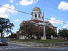 |
September 16, 1994 (#94001071) |
Jct. of N. Erwin and Cherokee Sts. 34°09′57″N 84°47′50″W / 34.165833°N 84.797222°W | Cartersville | ||
| 16 |  |
March 19, 1998 (#98000249) |
Roughly bounded by N. Wall, E. Church, and N. Gilmer Sts., and E. Cherokee Ave. 34°10′00″N 84°47′42″W / 34.166667°N 84.795°W | Cartersville | ||
| 17 | Old Bartow County Courthouse |  |
September 18, 1980 (#80000972) |
4 E. Church St. 34��10′02″N 84°47′45″W / 34.16726°N 84.79591°W | Cartersville | Now the Bartow History Museum |
| 18 |  |
September 9, 1988 (#86002176) |
GA 140, W of US 411 34°20′57″N 84°43′33″W / 34.349167°N 84.725833°W | Rydal | (See partial description at Rydal, Georgia) | |
| 19 | Roselawn |  |
January 12, 1973 (#73000607) |
244 Cherokee Ave. 34°09′54″N 84°48′10″W / 34.16513°N 84.80271°W | Cartersville | Now a museum |
| 20 |  |
April 22, 1999 (#99000412) |
Mac Johnson Rd. 34°14′03″N 84°50′44″W / 34.2343°N 84.84557°W | Cassville | ||
| 21 | May 8, 1974 (#74000657) |
Euharlee Rd., SW of Cartersville 34°08′23″N 84°52′04″W / 34.139722°N 84.867778°W | Cartersville |

References[]
- ^ National Park Service, United States Department of the Interior, "National Register of Historic Places: Weekly List Actions", retrieved January 28, 2022.
- ^ Numbers represent an alphabetical ordering by significant words. Various colorings, defined here, differentiate National Historic Landmarks and historic districts from other NRHP buildings, structures, sites or objects.
- ^ The eight-digit number below each date is the number assigned to each location in the National Register Information System database, which can be viewed by clicking the number.
- ^ "Noble Hill-Wheeler Memorial Center". Retrieved May 2, 2016.
| Wikimedia Commons has media related to National Register of Historic Places in Bartow County, Georgia. |
Categories:
- Lists of National Register of Historic Places in Georgia (U.S. state) by county
- Bartow County, Georgia
- National Register of Historic Places in Bartow County, Georgia