National Register of Historic Places listings in Dougherty County, Georgia
This is a list of properties and districts in Dougherty County, Georgia that are listed on the National Register of Historic Places (NRHP).
- This National Park Service list is complete through NPS recent listings posted January 28, 2022.[1]

Current listings[]
| [2] | Name on the Register | Image | Date listed[3] | Location | City or town | Description |
|---|---|---|---|---|---|---|
| 1 | 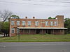 |
May 10, 1984 (#84000979) |
211-213 Roosevelt Ave. 31°34′53″N 84°09′06″W / 31.581389°N 84.151667°W | Albany | ||
| 2 | Albany Housefurnishing Company |  |
June 17, 1982 (#82002402) |
226 W. Broad Ave. 31°34′35″N 84°09′09″W / 31.576389°N 84.1525°W | Albany | |
| 3 | Albany Railroad Depot Historic District |  |
May 20, 1982 (#82002403) |
E. Roosevelt Ave. 31°34′55″N 84°09′00″W / 31.581944°N 84.15°W | Albany | |
| 4 | Albany Theatre |  |
August 21, 2006 (#06000733) |
107 N. Jackson St. 31°34′37″N 84°09′14″W / 31.576944°N 84.153889°W | Albany | |
| 5 | Bridge House |  |
November 19, 1974 (#74000672) |
112 N. Front St. 31°34′40″N 84°08′56″W / 31.577778°N 84.148889°W | Albany | |
| 6 |  |
July 15, 1982 (#82002404) |
215 N. Jackson St. 31°34′44″N 84°09′14″W / 31.578889°N 84.153889°W | Albany | ||
| 7 | John A. Davis House |  |
October 16, 1980 (#80001014) |
514 Pine Ave. 31°34′41″N 84°09′38″W / 31.578056°N 84.160556°W | Albany | |
| 8 | Davis-Exchange Bank Building |  |
February 23, 1984 (#84000981) |
100-102 N. Washington St. 31°34′37″N 84°09′04″W / 31.576944°N 84.151111°W | Albany | |
| 9 | Samuel Farkas House | 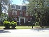 |
November 9, 1977 (#77000419) |
328 W. Broad Ave. 31°34′35″N 84°09′18″W / 31.576389°N 84.155°W | Albany | |
| 10 | March 18, 1996 (#96000214) |
1200 Fifth Ave. 31°35′34″N 84°10′42″W / 31.59280°N 84.17844°W | Albany | |||
| 11 |  |
March 18, 1996 (#96000213) |
711 Ninth Ave. 31°35′53″N 84°10′00″W / 31.598056°N 84.166667°W | Albany | Coordinates given are on the wrong block (a block to the south) | |
| 12 |  |
August 10, 1995 (#95000911) |
328 W. Whitney Ave. 31°34′18″N 84°09′20″W / 31.571667°N 84.155556°W | Albany | ||
| 13 | Municipal Auditorium | 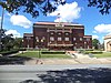 |
June 25, 1974 (#74000673) |
301 Pine Ave. 31°34′43″N 84°09′16″W / 31.578611°N 84.154444°W | Albany | |
| 14 | New Albany Hotel | 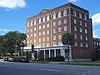 |
June 17, 1982 (#82002405) |
245 Pine St. 31°34′49″N 84°09′05″W / 31.58021°N 84.15133°W | Albany | |
| 15 | Old St. Teresa's Catholic Church | 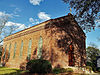 |
April 1, 1975 (#75000589) |
313 Residence Ave. 31°34′59″N 84°09′17″W / 31.583056°N 84.154722°W | Albany | |
| 16 | Rosenberg Brothers Department Store |  |
August 19, 1982 (#82002406) |
126 N. Washington St. 31°34′41″N 84°09′04″W / 31.578056°N 84.151111°W | Albany | Albany Herald Headquarters |
| 17 | 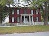 |
August 30, 1977 (#77000420) |
516 Flint Ave. 31°34′46″N 84°09′37″W / 31.579444°N 84.160278°W | Albany | First brick house in Albany | |
| 18 | St. Nicholas Hotel |  |
December 19, 1991 (#91001851) |
141 Flint Ave., 300-310 Washington St. 31°34′48″N 84°09′05″W / 31.58°N 84.151389°W | Albany | |
| 19 |  |
November 15, 1993 (#93001179) |
Bounded by N. Jefferson St., 5th Ave., 7th Ave. and Palmyra Rd. 31°35′38″N 84°09′31″W / 31.593889°N 84.158611°W | Albany | ||
| 20 | U.S. Post Office and Courthouse |  |
June 22, 1979 (#79003105) |
345 W. Broad Ave. 31°34′38″N 84°09′20″W / 31.577222°N 84.155556°W | Albany | |
| 21 | Union Station Depot |  |
February 13, 1975 (#75000590) |
Roosevelt Ave. and N. Front St. 31°34′54″N 84°08′59″W / 31.581579°N 84.149652°W | Albany |

References[]
- ^ National Park Service, United States Department of the Interior, "National Register of Historic Places: Weekly List Actions", retrieved January 28, 2022.
- ^ Numbers represent an alphabetical ordering by significant words. Various colorings, defined here, differentiate National Historic Landmarks and historic districts from other NRHP buildings, structures, sites or objects.
- ^ The eight-digit number below each date is the number assigned to each location in the National Register Information System database, which can be viewed by clicking the number.
| Wikimedia Commons has media related to National Register of Historic Places in Dougherty County, Georgia. |
Categories:
- Lists of National Register of Historic Places in Georgia (U.S. state) by county
- Buildings and structures in Dougherty County, Georgia
- National Register of Historic Places in Dougherty County, Georgia