From Wikipedia, the free encyclopedia
This is a list of properties and districts in Jackson County, Georgia that are listed on the National Register of Historic Places (NRHP).
This National Park Service list is complete through NPS recent listings posted January 28, 2022. [1]
Current listings [ ]
[2] Name on the Register
Image
Date listed[3]
Location
City or town
Description
1
April 27, 2001 (#01000384 ) Jct. of GA 124 and GA 53 34°06′33″N 83°45′48″W / 34.109167°N 83.763333°W / 34.109167; -83.763333 (Braselton Historic District ) Braselton
2
January 19, 1989 (#88003226 ) Roughly bounded by Line, State, Cherry, Sycamore and Broad Sts. 34°12′13″N 83°27′24″W / 34.203611°N 83.456667°W / 34.203611; -83.456667 (Commerce Commercial Historic District ) Commerce
3
Governor L. G. Hardman House Upload image June 16, 1988 (#88000749 ) 208 Elm St. 34°12′04″N 83°27′22″W / 34.201111°N 83.456111°W / 34.201111; -83.456111 (Governor L. G. Hardman House ) Commerce
4
May 2, 1985 (#85000936 ) GA 53 & Peachtree Rd. 34°05′18″N 83°45′29″W / 34.088333°N 83.758056°W / 34.088333; -83.758056 (Hillcrest-Allen Clinic and Hospital ) Hoschton
5
Holder Plantation Upload image September 5, 1990 (#90001408 ) Jct. of Possum Creek Rd. and US 129 34°09′03″N 83°37′13″W / 34.150833°N 83.620278°W / 34.150833; -83.620278 (Holder Plantation ) Jefferson
6
March 31, 2000 (#00000304 ) 4276 GA 53 34°05′49″N 83°45′41″W / 34.096944°N 83.761389°W / 34.096944; -83.761389 (Hoschton Depot ) Hoschton
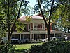
7
Jackson County Courthouse
September 18, 1980 (#80001096 ) GA 1 34°07′06″N 83°34′28″W / 34.118333°N 83.574444°W / 34.118333; -83.574444 (Jackson County Courthouse ) Jefferson
8
March 26, 2003 (#03000137 ) Roughly centered on the downtown central business district of Jefferson extending to city limits to NW and SW 34°07′01″N 83°34′42″W / 34.116944°N 83.578333°W / 34.116944; -83.578333 (Jefferson Historic District ) Jefferson
9
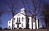
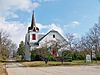
Maysville Historic District
September 12, 1985 (#85002203 ) Along E. Main, W. Main and Homer Sts. 34°15′17″N 83°33′48″W / 34.254722°N 83.563333°W / 34.254722; -83.563333 (Maysville Historic District ) Maysville
10
Upload image May 30, 2002 (#02000564 ) S of jct. of Oak Ave. and the Southern RR 34°06′36″N 83°34′47″W / 34.11°N 83.579722°W / 34.11; -83.579722 (Oak Avenue Historic District ) Jefferson
11
May 30, 2002 (#02000563 ) E of Southern RR bet. Lawrenceville St. and Mahaffey Circle 34°07′08″N 83°34′56″W / 34.118889°N 83.582222°W / 34.118889; -83.582222 (Paradise Cemetery ) Jefferson
12
Seaborn M. Shankle House Upload image November 29, 1979 (#79000732 ) 125 Cherry St 34°12′09″N 83°27′18″W / 34.2025°N 83.455°W / 34.2025; -83.455 (Seaborn M. Shankle House ) Commerce
13
Upload image June 25, 1992 (#92000814 ) Jct. of GA 319 and Co. Rd. 125, approximately 5 mi. SW of Jefferson 34°04′05″N 83°35′27″W / 34.068056°N 83.590833°W / 34.068056; -83.590833 (Shields-Etheridge Farm ) Jackson
14
September 15, 1997 (#97000960 ) Roughly along Main St., Kinney Ave., and A.J. Irvin Rd. 34°11′06″N 83°43′13″W / 34.185°N 83.720278°W / 34.185; -83.720278 (Talmo Historic District ) Talmo
15
Upload image July 7, 1995 (#95000823 ) GA 15 NE of Jefferson 34°08′52″N 83°31′10″W / 34.147778°N 83.519444°W / 34.147778; -83.519444 (Williamson-Maley-Turner Farm ) Jefferson
References [ ] Categories :
Lists of National Register of Historic Places in Georgia (U.S. state) by county Buildings and structures in Jackson County, Georgia National Register of Historic Places in Jackson County, Georgia Hidden categories:
Lists of coordinates Geographic coordinate lists Articles with Geo Commons category link is on Wikidata