From Wikipedia, the free encyclopedia
Map showing Washington County in Georgia
This is a list of properties and districts in Washington County, Georgia that are listed on the National Register of Historic Places (NRHP).
This National Park Service list is complete through NPS recent listings posted January 28, 2022. [1]
Current listings [ ]
[2] Name on the Register
Image
Date listed[3]
Location
City or town
Description
1
Church-Smith-Harris Street Historic District Upload image December 31, 1987 (#87001268 ) E. Church, S. Smith, and S. Harris Sts. 32°58′44″N 82°48′29″W / 32.978889°N 82.808056°W / 32.978889; -82.808056 (Church-Smith-Harris Street Historic District ) Sandersville
2
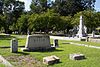
City Cemetery
August 3, 1987 (#87001296 ) W. Church, Cemetery, and Haynes Sts. 32°58′57″N 82°48′55″W / 32.9825°N 82.815278°W / 32.9825; -82.815278 (City Cemetery ) Sandersville
3
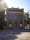
Thomas Jefferson Elder High and Industrial School
May 12, 1981 (#81000202 ) 316 Hall St. 32°58′38″N 82°48′58″W / 32.97730°N 82.81605°W / 32.97730; -82.81605 (Thomas Jefferson Elder High and Industrial School ) Sandersville
4
Upload image January 26, 2005 (#04001556 ) 1200 GA 242/Riddleville Rd. 32°57′51″N 82°47′25″W / 32.96416°N 82.79021°W / 32.96416; -82.79021 (Forest Grove ) Sandersville library web page
5
Upload image July 3, 1975 (#75000616 ) SE of Davisboro on SR 2189 (Josey Church Road?) 32°55′52″N 82°33′28″W / 32.931111°N 82.557778°W / 32.931111; -82.557778 (Francis Plantation ) Davisboro
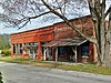
6
Holt Brothers Banking Company Building
July 28, 1994 (#94000710 ) 100-106 Malone St. 32°59′02″N 82°48′39″W / 32.98385°N 82.81092°W / 32.98385; -82.81092 (Holt Brothers Banking Company Building ) Sandersville
7
July 28, 1994 (#94000711 ) 425 W. Church St. 32°58′54″N 82°49′03″W / 32.98155°N 82.81745°W / 32.98155; -82.81745 (James E. Johnson House ) Sandersville
8
James Kelley House Upload image July 28, 1994 (#94000712 ) Tennille-Harrison Rd. E of jct. with GA 15 32°55′53″N 82°48′01″W / 32.93130°N 82.80018°W / 32.93130; -82.80018 (James Kelley House ) Tennille
9
Charles Madden House
July 28, 1994 (#94000713 ) 302 E. South Central St. 32°56′12″N 82°48′28″W / 32.93677°N 82.80790°W / 32.93677; -82.80790 (Charles Madden House ) Tennille
10
North Harris Street Historic District Upload image July 20, 1989 (#89000801 ) Roughly bounded by First Ave., Washington Ave., E. McCarty St., N. Harris St., Malone St., and Warthen St. 32°59′20″N 82°48′37″W / 32.988889°N 82.810278°W / 32.988889; -82.810278 (North Harris Street Historic District ) Sandersville
11
March 1, 2002 (#02000120 ) Roughly Jernigan, Gilmore, North Smith, East Haynes, W. Haynes, and Warthen Sts. 32°59′03″N 82°48′35″W / 32.984167°N 82.809722°W / 32.984167; -82.809722 (Sandersville Commercial and Industrial District ) Sandersville
12
Upload image December 9, 2019 (#100004745 ) 514 North Harris St. 32°59′41″N 82°48′33″W / 32.9946°N 82.8091°W / 32.9946; -82.8091 (Sandersville High School ) Sandersville
13
July 28, 1994 (#94000714 ) 306 N. Main St. 32°56′21″N 82°48′38″W / 32.939141°N 82.81049°W / 32.939141; -82.81049 (Thomas W. Smith House ) Tennille
14
Tennille Banking Company Building
July 28, 1994 (#94000715 ) 102-104 N. Main St. 32°56′11″N 82°48′41″W / 32.936389°N 82.811389°W / 32.936389; -82.811389 (Tennille Banking Company Building ) Tennille
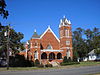
15
Tennille Baptist Church
July 28, 1994 (#94000716 ) 201-205 N. Main St. 32°56′20″N 82°48′41″W / 32.93876°N 82.81137°W / 32.93876; -82.81137 (Tennille Baptist Church ) Tennille
16
Tennille Woman's Clubhouse
July 1, 1998 (#98000815 ) 132 Smith St. 32°56′16″N 82°48′45″W / 32.93777°N 82.81259°W / 32.93777; -82.81259 (Tennille Woman's Clubhouse ) Tennille
17
Warthen Historic District
July 25, 1997 (#97000755 ) Jct. of GA 15, GA 102, Warthen St., Old Sadersville-Sparta and Walker Dairy Rds. 33°06′12″N 82°48′18″W / 33.103333°N 82.805°W / 33.103333; -82.805 (Warthen Historic District ) Warthen
18
Washington County Courthouse
September 18, 1980 (#80001260 ) Courthouse Sq. 32°59′00″N 82°48′43″W / 32.983333°N 82.811944°W / 32.983333; -82.811944 (Washington County Courthouse ) Sandersville Is also in the
19
Upload image July 28, 1994 (#94000717 ) Between E. Montgomery and Church Sts. at White Line St. 32°56′33″N 82°48′16″W / 32.94241°N 82.80443°W / 32.94241; -82.80443 (Washington Manufacturing Company ) Tennille Main building has been demolished
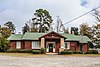
20
Wrightsville and Tennille Railroad Company Building
July 28, 1994 (#94000718 ) 119 Central Ave. 32°56′06″N 82°48′46″W / 32.93500°N 82.81276°W / 32.93500; -82.81276 (Wrightsville and Tennille Railroad Company Building ) Tennille
References [ ] Categories :
Lists of National Register of Historic Places in Georgia (U.S. state) by county Washington County, Georgia National Register of Historic Places in Washington County, Georgia Hidden categories:
Lists of coordinates Geographic coordinate lists Articles with Geo Commons category link is on Wikidata