National Register of Historic Places listings in Twiggs County, Georgia
This is a list of properties and districts in Twiggs County, Georgia that are listed on the National Register of Historic Places (NRHP).
- This National Park Service list is complete through NPS recent listings posted January 28, 2022.[1]

Current listings[]
| [2] | Name on the Register | Image | Date listed[3] | Location | City or town | Description |
|---|---|---|---|---|---|---|
| 1 | January 15, 1998 (#97001648) |
Address Restricted | Jeffersonville | |||
| 2 | 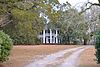 |
August 11, 1982 (#82002491) |
SE of Jeffersonville on GA 96 (address is 1286 as of 2017) 32°40′45″N 83°18′48″W / 32.67917°N 83.31332°W | Jeffersonville | ||
| 3 | Myrick's Mill |  |
December 6, 1975 (#75000613) |
NE of Fitzpatrick on county road 378 32°47′02″N 83°22′05″W / 32.783889°N 83.368056°W | Fitzpatrick | Historical marker at 32°47′41″N 83°22′21″W / 32.79483°N 83.37250°W |
| 4 |  |
January 25, 2021 (#100006053) |
213 Shannon Dr. 32°41′06″N 83°20′45″W / 32.6851°N 83.3458°W | Jeffersonville | ||
| 5 |  |
June 22, 1982 (#82002492) |
Richland Rd. 32°37′50″N 83°24′02″W / 32.63052°N 83.40064°W | Jeffersonville | ||
| 6 | Twiggs County Courthouse |  |
September 18, 1980 (#80001248) |
Courthouse Sq. 32°41′15″N 83°20′45″W / 32.6875°N 83.345833°W | Jeffersonville | Built 1902-04, later expanded (between 1980 and 2015) |
| 7 | 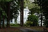 |
June 17, 1982 (#82002493) |
Jeffersonville Rd., GA 96 32°38′18″N 83°22′04″W / 32.63821°N 83.36767°W | Jeffersonville |

References[]
- ^ National Park Service, United States Department of the Interior, "National Register of Historic Places: Weekly List Actions", retrieved January 28, 2022.
- ^ Numbers represent an alphabetical ordering by significant words. Various colorings, defined here, differentiate National Historic Landmarks and historic districts from other NRHP buildings, structures, sites or objects.
- ^ The eight-digit number below each date is the number assigned to each location in the National Register Information System database, which can be viewed by clicking the number.
| Wikimedia Commons has media related to National Register of Historic Places in Twiggs County, Georgia. |
Categories:
- Lists of National Register of Historic Places in Georgia (U.S. state) by county
- Twiggs County, Georgia
- National Register of Historic Places in Twiggs County, Georgia