From Wikipedia, the free encyclopedia
Map of Georgia with Spalding County highlighted
This is a list of properties and districts in Spalding County, Georgia that are listed on the National Register of Historic Places (NRHP).
This National Park Service list is complete through NPS recent listings posted January 28, 2022. [1]
Current listings [ ]
[2] Name on the Register
Image
Date listed[3]
Location
City or town
Description
1
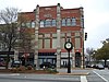
Sam Bailey Building
March 20, 1973 (#73002144 ) E. Poplar and 4th Sts. 33°14′47″N 84°15′35″W / 33.246389°N 84.259722°W / 33.246389; -84.259722 (Sam Bailey Building ) Griffin
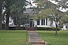
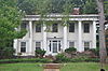
2
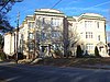
Bailey-Tebault House
March 20, 1973 (#73002146 ) 633 Meriwether St. 33°14′39″N 84°16′25″W / 33.244167°N 84.273611°W / 33.244167; -84.273611 (Bailey-Tebault House ) Griffin Now houses the Griffin/Spalding Historical Society.
3
Double Cabins
March 7, 1973 (#73002147 ) NE of Griffin on GA 16 (3335 Jackson Road) 33°17′38″N 84°11′36″W / 33.29384°N 84.19322°W / 33.29384; -84.19322 (Double Cabins ) Griffin
4
Griffin Commercial Historic District
November 16, 1988 (#88002310 ) Roughly bounded by Central Alley, Sixth, Taylor and Eighth Sts. 33°14′57″N 84°15′51″W / 33.249167°N 84.264167°W / 33.249167; -84.264167 (Griffin Commercial Historic District ) Griffin Building on N. Hill St. (GA 155) and E Solomon St. Built in 1894
5
March 20, 1973 (#73002140 ) 210 S. 6th St. 33°14′47″N 84°15′40″W / 33.246389°N 84.261111°W / 33.246389; -84.261111 (Hawkes Library ) Griffin
6
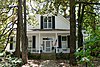
Hill-Kurtz House
March 20, 1973 (#73002141 ) 570 S. Hill St. 33°14′08″N 84°15′45″W / 33.235556°N 84.2625°W / 33.235556; -84.2625 (Hill-Kurtz House ) Griffin
7
Hunt House Upload image March 26, 1973 (#73002142 ) 232 S. 8th St. 33°15′44″N 84°18′59″W / 33.262222°N 84.316389°W / 33.262222; -84.316389 (Hunt House ) Griffin Moved from 232 S. 8th St. in 1978[4]
8
Marian Apartments
September 10, 2007 (#07000936 ) 400 W. Poplar St. 33°14′44″N 84°16′09″W / 33.245556°N 84.269167°W / 33.245556; -84.269167 (Marian Apartments ) Griffin
9
Mills House
October 18, 1972 (#72001468 ) 406 N. Hill St. 33°15′14″N 84°15′47″W / 33.254°N 84.263°W / 33.254; -84.263 (Mills House ) Griffin
10
Mills House and Smokehouse Upload image January 20, 1980 (#80004308 ) S of Griffin at 1590 Carver Rd. 33°12′34″N 84°17′44″W / 33.20943°N 84.29543°W / 33.20943; -84.29543 (Mills House and Smokehouse ) Griffin
11
December 19, 2019 (#100004786 ) 708 South Hill St. 33°14′09″N 84°15′51″W / 33.2358°N 84.2643°W / 33.2358; -84.2643 (Milner-Walker House ) Griffin
12
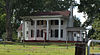
Old Gaissert Homeplace
June 4, 1973 (#73002145 ) NE of Williamson on GA 362 33°12′30″N 84°20′00″W / 33.20834°N 84.33337°W / 33.20834; -84.33337 (Old Gaissert Homeplace ) Williamson
13
December 15, 1972 (#72001469 ) 223-233 E. Broadway St. 33°15′04″N 84°15′40″W / 33.251111°N 84.261111°W / 33.251111; -84.261111 (Old Medical College Historical Area ) Griffin
14
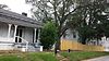
Pritchard-Moore-Goodrich House
March 7, 1973 (#73002143 ) 441 N. Hill St. 33°15′18″N 84°15′51″W / 33.2551°N 84.26411°W / 33.2551; -84.26411 (Pritchard-Moore-Goodrich House ) Griffin
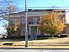
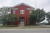
15
Spalding County Courthouse-Spalding County Jail
November 22, 2000 (#00001389 ) 232 E. Broad St. 33°14′59″N 84°15′38″W / 33.249722°N 84.260556°W / 33.249722; -84.260556 (Spalding County Courthouse-Spalding County Jail ) Griffin
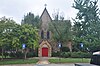
16
St. George's Episcopal Church
April 7, 1994 (#94000284 ) 132 N. Tenth St. 33°14′59″N 84°16′06″W / 33.249722°N 84.268333°W / 33.249722; -84.268333 (St. George's Episcopal Church ) Griffin
References [ ] Categories :
Lists of National Register of Historic Places in Georgia (U.S. state) by county Buildings and structures in Spalding County, Georgia National Register of Historic Places in Spalding County, Georgia Hidden categories:
Lists of coordinates Geographic coordinate lists Articles with Geo Commons category link is on Wikidata