National Register of Historic Places listings in Crisp County, Georgia
This is a list of properties and districts in Crisp County, Georgia that are listed on the National Register of Historic Places (NRHP).
- This National Park Service list is complete through NPS recent listings posted January 28, 2022.[1]

Current listings[]
| [2] | Name on the Register | Image | Date listed[3] | Location | City or town | Description |
|---|---|---|---|---|---|---|
| 1 | September 5, 1975 (#75000587) |
Address Restricted | Cordele | Prehistoric graves, on private land | ||
| 2 | Cordele Commercial Historic District | 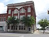 |
July 6, 1989 (#89000803) |
Roughly bounded by Sixth Ave., Sixth St., Ninth Ave., and Fourteenth St. 31°58′12″N 83°46′57″W / 31.97°N 83.7825°W | Cordele | Includes a 1907 Masonic Lodge designed in Beaux Arts style by architect T. Firth Lockwood, Sr.. |
| 3 | December 2, 1998 (#97000336) |
Roughly bounded by Railroad, 10th, and 15th Sts., and 16th Ave. 31°57′55″N 83°47′27″W / 31.96523°N 83.79083°W | Cordele | African-American neighborhood, including the | ||
| 4 | October 6, 2004 (#04000339) |
Roughly bounded by the Seaboard Coastline Railroad, Owens St. 16th Ave. and 6th St. 31°57′59″N 83°46′31″W / 31.966389°N 83.775278°W | Cordele | |||
| 5 | US Post Office-Cordele | 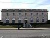 |
June 29, 1984 (#84000977) |
102-104 6th St. 31°58′08″N 83°46′53″W / 31.96880°N 83.78135°W | Cordele |

References[]
- ^ National Park Service, United States Department of the Interior, "National Register of Historic Places: Weekly List Actions", retrieved January 28, 2022.
- ^ Numbers represent an alphabetical ordering by significant words. Various colorings, defined here, differentiate National Historic Landmarks and historic districts from other NRHP buildings, structures, sites or objects.
- ^ The eight-digit number below each date is the number assigned to each location in the National Register Information System database, which can be viewed by clicking the number.
| Wikimedia Commons has media related to National Register of Historic Places in Crisp County, Georgia. |
Categories:
- Lists of National Register of Historic Places in Georgia (U.S. state) by county
- Buildings and structures in Crisp County, Georgia
- National Register of Historic Places in Crisp County, Georgia