From Wikipedia, the free encyclopedia
This is a list of properties and districts in Morgan County, Georgia that are listed on the National Register of Historic Places (NRHP).
This National Park Service list is complete through NPS recent listings posted January 28, 2022. [1]
Current listings [ ]
[2] Name on the Register
Image
Date listed[3]
Location
City or town
Description
1
May 26, 2000 (#00000527 ) 5060 Lower Apalachee Rd. 33°41′22″N 83°26′10″W / 33.689444°N 83.436111°W / 33.689444; -83.436111 (Apalachee School ) Apalachee
2
Upload image November 13, 1974 (#74000695 ) Dixie Ave. 33°35′12″N 83°29′17″W / 33.586667°N 83.488056°W / 33.586667; -83.488056 (Nathan Bennett House ) Madison
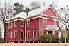
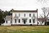
3
Bonar Hall
January 20, 1972 (#72000388 ) Dixie Ave. 33°35′15″N 83°28′54″W / 33.5875°N 83.4817°W / 33.5875; -83.4817 (Bonar Hall ) Madison
4
Bostwick Historic District Upload image October 22, 2002 (#02001221 ) Jct. of Bostwick Rd. and Fairplay Rd. 33°44′12″N 83°30′55″W / 33.736667°N 83.515278°W / 33.736667; -83.515278 (Bostwick Historic District ) Bostwick
5
Buckhead Historic District Upload image March 1, 2002 (#02000097 ) Roughly bounded by Main St. and Parks Mill, Seven Islands and Baldwin Dairy Rds. 33°34′01″N 83°21′41″W / 33.566944°N 83.361389°W / 33.566944; -83.361389 (Buckhead Historic District ) Buckhead
6
Cedar Lane Farm Upload image February 24, 1971 (#71000281 ) N of Madison off GA 83 33°39′30″N 83°30′54″W / 33.658333°N 83.515°W / 33.658333; -83.515 (Cedar Lane Farm ) Madison
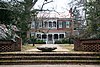
7
Hard Labor Creek State Park
March 27, 2013 (#13000107 ) Fairplay & Knox Chapel Rds. 33°39′35″N 83°36′08″W / 33.659627°N 83.602116°W / 33.659627; -83.602116 (Hard Labor Creek State Park ) Rutledge vicinity
8
Madison Historic District
October 29, 1974 (#74000696 ) Roughly bounded on both sides by U.S. 441 (original); Roughly Main St., Old Post Rd., Academy St., Dixie St., and Washington St. (increase) 33°35′37″N 83°28′16″W / 33.593611°N 83.471111°W / 33.593611; -83.471111 (Madison Historic District ) Madison Boundary increase approved on January 8, 1990.
9
June 28, 2019 (#100004106 ) 4690 A Bostwick Hwy. 33°42′29″N 83°29′59″W / 33.7080°N 83.4998°W / 33.7080; -83.4998 (James A. Nolan House ) Madison
10
John O'Flaherty House Upload image August 29, 1991 (#91001155 ) 1000 Oconee Rd. 33°34′07″N 83°21′35″W / 33.568611°N 83.359722°W / 33.568611; -83.359722 (John O'Flaherty House ) Buckhead
11
Upload image May 22, 2003 (#03000429 ) Centered along Main St., The Georgia Railroad (CSX), E. Dixis Hwy, and Fairplay Rd. 33°37′35″N 83°36′44″W / 33.626389°N 83.612222°W / 33.626389; -83.612222 (Rutledge Historic District ) Rutledge
12
July 1, 1994 (#94000664 ) Main St. 33°44′14″N 83°30′52″W / 33.737222°N 83.514444°W / 33.737222; -83.514444 (Susie Agnes Hotel ) Bostwick
13
Wilson-Finney-Land House
February 11, 2004 (#04000021 ) 1750 Bethany Rd. 33°34′38″N 83°27′13″W / 33.577222°N 83.453611°W / 33.577222; -83.453611 (Wilson-Finney-Land House ) Madison
14
Zachry-Kingston House
May 18, 1987 (#87000796 ) 6030 Bethany Rd. 33°30′41″N 83°19′51″W / 33.511389°N 83.330833°W / 33.511389; -83.330833 (Zachry-Kingston House ) Buckhead
References [ ] Categories :
Lists of National Register of Historic Places in Georgia (U.S. state) by county Buildings and structures in Morgan County, Georgia National Register of Historic Places in Morgan County, Georgia Hidden categories:
Lists of coordinates Geographic coordinate lists Articles with Geo Commons category link is on Wikidata