From Wikipedia, the free encyclopedia
This is a list of properties and districts in Carroll County, Georgia that are listed on the National Register of Historic Places (NRHP).
This National Park Service list is complete through NPS recent listings posted January 28, 2022. [1]
Current listings [ ]
[2] Name on the Register
Image
Date listed[3]
Location
City or town
Description
1
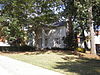
May 13, 1970 (#70000198 ) University of West Georgia campus 33°34′17″N 85°05′53″W / 33.571389°N 85.098056°W / 33.571389; -85.098056 (Bonner-Sharp-Gunn House ) Carrollton
2
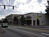
December 8, 2009 (#09001056 ) Roughly centered along Georgia State Route 166 and Georgia State Route 100 33°32′17″N 85°15′12″W / 33.538189°N 85.253344°W / 33.538189; -85.253344 (Bowdon Historic District ) Bowdon
3
Upload image August 29, 1977 (#77001539 ) Address Restricted Carrollton
4
Carroll County Courthouse
September 18, 1980 (#80000985 ) Newnan and Dixie Sts. 33°34′46″N 85°04′22″W / 33.579444°N 85.072778°W / 33.579444; -85.072778 (Carroll County Courthouse ) Carrollton Built in 1928
5
May 1, 2007 (#07000378 ) Roughly around downtown sq. and is bounded by Johnson Ave., White St., Mill St. and Barnes St. 33°34′48″N 85°04′26″W / 33.580031°N 85.073878°W / 33.580031; -85.073878 (Carrollton Downtown Historic District ) Carrollton
6
Dorough Round Barn and Farm
January 20, 1980 (#80000986 ) N of Hickory Level on Villa Rica Rd. 33°41′07″N 84°59′18″W / 33.685278°N 84.988333°W / 33.685278; -84.988333 (Dorough Round Barn and Farm ) Hickory Level
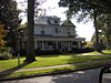
7
August 24, 2005 (#05000902 ) 1575 GA 16 33°38′10″N 85°02′16″W / 33.636111°N 85.037778°W / 33.636111; -85.037778 (Eric Vernon Folds House ) Carrollton
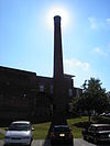
8
January 26, 2005 (#04001558 ) 301 Bradley St. 33°34′40″N 85°04′34″W / 33.577778°N 85.076111°W / 33.577778; -85.076111 (Lawler Hosiery Mill ) Carrollton
9
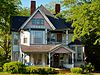
Dr. James L. Lovvorn House
May 19, 1988 (#88000595 ) 113 E. College St. 33°32′18″N 85°15′11″W / 33.538333°N 85.253056°W / 33.538333; -85.253056 (Dr. James L. Lovvorn House ) Bowdon
10
April 19, 2006 (#06000287 ) Roughly centered on Aycock, Lovvorn, and Burson Sts. 33°34′46″N 85°05′19″W / 33.579444°N 85.088611°W / 33.579444; -85.088611 (Mandeville Mills and Mill Village Historic District ) Carrollton
11
May 24, 1990 (#90000803 ) 1238 SR 166 W. 33°32′36″N 85°16′35″W / 33.543333°N 85.276389°W / 33.543333; -85.276389 (McDaniel-Huie Place ) Bowdon
12
North Villa Rica Commercial Historic District
December 31, 2002 (#02001635 ) Roughly bounded by Southern Railroad, North Ave., and East Gordon and West Church Sts. 33°43′56″N 84°55′30″W / 33.732222°N 84.925°W / 33.732222; -84.925 (North Villa Rica Commercial Historic District ) Villa Rica
13
June 28, 1984 (#84000947 ) Roughly bounded by RR tracks, Harmon and West Aves., Bradley, Mill and Garrett Sts., Tillman and Hill Drs. 33°34′32″N 85°04′20″W / 33.575556°N 85.072222°W / 33.575556; -85.072222 (South Carrollton Residential Historic District ) Carrollton
14
April 18, 1983 (#83000185 ) 402 Newnan St. 33°34′48″N 85°04′21″W / 33.58°N 85.0725°W / 33.58; -85.0725 (U.S. Post Office ) Carrollton
15
Veal School
December 22, 2005 (#05001427 ) 2753 Old Columbus Rd. 33°26′08″N 85°13′55″W / 33.435556°N 85.231944°W / 33.435556; -85.231944 (Veal School ) Roopville
16
October 22, 2002 (#02001220 ) 662 Main St. 33°29′35″N 84°54′50″W / 33.493056°N 84.913889°W / 33.493056; -84.913889 (Whitesburg Baptist Church ) Whitesburg
17
Williams Family Farm
March 25, 2005 (#05000193 ) 55 Goldworth Rd. 33°42′12″N 84°56′36″W / 33.703333°N 84.943333°W / 33.703333; -84.943333 (Williams Family Farm ) Villa Rica
References [ ] Categories :
Lists of National Register of Historic Places in Georgia (U.S. state) by county Buildings and structures in Carroll County, Georgia National Register of Historic Places in Carroll County, Georgia Hidden categories:
Lists of coordinates Geographic coordinate lists Articles with Geo Commons category link is on Wikidata