National Register of Historic Places listings in Habersham County, Georgia
This is a list of properties and districts in Habersham County, Georgia that are listed on the National Register of Historic Places (NRHP).
- This National Park Service list is complete through NPS recent listings posted January 28, 2022.[1]

Current listings[]
| [2] | Name on the Register | Image | Date listed[3] | Location | City or town | Description |
|---|---|---|---|---|---|---|
| 1 | Acoa | June 22, 1982 (#82002446) |
Mathis Rd. 34°39′09″N 83°28′16″W / 34.65251°N 83.47111°W | Hollywood | ||
| 2 | Henry Asbury House | 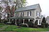 |
August 18, 1982 (#82002425) |
211 E. Waters St. 34°37′01″N 83°31′26″W / 34.616944°N 83.523889°W | Clarkesville | |
| 3 | 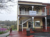 |
August 18, 1982 (#82002426) |
714 N. Washington St. 34°36′56″N 83°31′34″W / 34.615556°N 83.526111°W | Clarkesville | ||
| 4 | Chenocetah Fire Tower |  |
June 11, 1984 (#84001110) |
Chenocetah Mountain 34°30′08″N 83°30′25″W / 34.502222°N 83.506944°W | Cornelia | |
| 5 | August 18, 1982 (#82002427) |
N. Washington St. 34°36′53″N 83°31′32″W / 34.614722°N 83.525556°W | Clarkesville | North corner of Washington and Green | ||
| 6 | November 18, 2021 (#100006669) |
Along Washington St. (US 441/23), roughly bounded by Jefferson, Morgan, Madison, Water, Monroe, and Grant Sts. 34°36′53″N 83°31′32″W / 34.6146°N 83.5256°W | Clarkesville | |||
| 7 | August 18, 1982 (#82002429) |
304 N. Washington St. 34°36′52″N 83°31′32″W / 34.61456°N 83.52546°W | Clarkesville | SE corner of Washington and Green | ||
| 8 | January 3, 2022 (#100007277) |
Centered around intersection of Main and Irvin Sts. 34°30′41″N 83°31′38″W / 34.5114°N 83.5271°W | Cornelia | |||
| 9 | August 18, 1982 (#82002428) |
304 N. Washington St. 34°36′53″N 83°31′30″W / 34.61462°N 83.52501°W | Clarkesville | |||
| 10 | 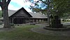 |
June 21, 1982 (#82002445) |
U.S. 123 at LaVista Lane 34°30′47″N 83°31′08″W / 34.513056°N 83.518889°W | Cornelia | ||
| 11 | August 18, 1982 (#82002430) |
N. Washington St. 34°36′56″N 83°31′41″W / 34.615556°N 83.528056°W | Clarkesville | |||
| 12 | Demorest Commercial Historic District | October 16, 1989 (#89001713) |
Georgia St. and Central Ave. 34°33′54″N 83°32′43″W / 34.565°N 83.545278°W | Demorest | ||
| 13 | Demorest Women's Club | 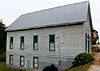 |
December 30, 2008 (#08001247) |
1035 Central Ave. 34°33′59″N 83°32′39″W / 34.5664°N 83.5443°W | Demorest | |
| 14 |  |
August 18, 1982 (#82002431) |
223 Grant St. 34°37′06″N 83°31′27″W / 34.618333°N 83.524167°W | Clarkesville | ||
| 15 | 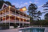 |
January 4, 1990 (#89002270) |
SW of Tallulah Falls on Co. Rd. 218 34°43′12″N 83°26′54″W / 34.72°N 83.448333°W | Turnerville | ||
| 16 | Grace Church |  |
February 15, 1980 (#80001087) |
Wilson and Greene Sts. 34°36′58″N 83°31′24″W / 34.616111°N 83.523333°W | Clarkesville | |
| 17 |  |
August 18, 1982 (#82002432) |
Bridge St. 34°37′02″N 83°31′37″W / 34.617222°N 83.526944°W | Clarkesville | ||
| 18 |  |
December 19, 1991 (#91001852) |
GA 115 W of jct. with Habersham Rd. 34°36′25″N 83°34′26″W / 34.606944°N 83.573889°W | Clarkesville | ||
| 19 | A. P. Hill House | August 18, 1982 (#82002433) |
N. Washington St. 34°36′48″N 83°31′30″W / 34.613333°N 83.525°W | Clarkesville | ||
| 20 | July 26, 1984 (#84001113) |
Irvin St. 34°30′40″N 83°31′40″W / 34.511111°N 83.527778°W | Cornelia | |||
| 21 | 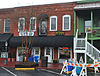 |
August 18, 1982 (#82002434) |
710 N. Washington St. 34°36′56″N 83°31′33″W / 34.615556°N 83.525833°W | Clarkesville | ||
| 22 |  |
August 18, 1982 (#82002435) |
712 N. Washington St. 34°36′56″N 83°31′34″W / 34.615556°N 83.526111°W | Clarkesville | ||
| 23 | January 8, 2009 (#08001282) |
136 7th St. 34°31′01″N 83°29′58″W / 34.5170°N 83.4995°W | Mount Airy | |||
| 24 |  |
August 18, 1982 (#82002436) |
N. Washington St. 34°36′48″N 83°31′27″W / 34.613333°N 83.524167°W | Clarkesville | ||
| 25 |  |
February 9, 2001 (#01000079) |
271 Foreacre St. 34°30′42″N 83°31′28″W / 34.511667°N 83.524444°W | Cornelia | ||
| 26 | Market Building | August 18, 1982 (#82002437) |
N. Washington St. 34°36′56″N 83°31′41″W / 34.615556°N 83.528056°W | Clarkesville | ||
| 27 | Mauldin House | 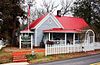 |
August 18, 1982 (#82002438) |
102 E. Water St. 34°36′56″N 83°31′31″W / 34.615556°N 83.525278°W | Clarkesville | |
| 28 | August 18, 1982 (#82002439) |
Allen Lane 34°36′20″N 83°31′08″W / 34.605556°N 83.518889°W | Clarkesville | |||
| 29 | August 18, 1982 (#82002440) |
403 S. Washington St. 34°36′16″N 83°31′11″W / 34.604444°N 83.519722°W | Clarkesville | |||
| 30 | July 9, 1997 (#97000753) |
Jct. of Pea Ridge Rd. and Paradise Park Rd. 34°32′21″N 83°35′44″W / 34.539167°N 83.595556°W | ||||
| 31 | 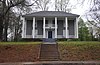 |
August 18, 1982 (#82002441) |
Bridge St. 34°37′03″N 83°31′38″W / 34.6175°N 83.527222°W | Clarkesville | ||
| 32 |  |
June 23, 2003 (#03000537) |
202 Massachusetts Bvd. 34°33′53″N 83°32′34″W / 34.564722°N 83.542778°W | Demorest | ||
| 33 | August 18, 1982 (#82002442) |
N. Washington St. 34°36′53″N 83°31′37″W / 34.614722°N 83.526944°W | Clarkesville | |||
| 34 | August 18, 1982 (#82002443) |
S. Washington St. between Laurel Dr. and Spring St. 34°36′26″N 83°31′17″W / 34.607222°N 83.521389°W | Clarkesville | |||
| 35 | Tallulah Falls School |  |
January 30, 1992 (#91002026) |
Jct. of US 441 and Tallulah School Rd. 34°43′54″N 83°23′36″W / 34.731667°N 83.393333°W | Tallulah Falls | |
| 36 | Washington-Jefferson Street Historic District | August 18, 1982 (#82002444) |
Washington, Jefferson, and Wilson Sts. between Green St. and Laurel Dr. 34°36′49″N 83°31′21″W / 34.613611°N 83.5225°W | Clarkesville | ||
| 37 | December 30, 1975 (#75002121) |
3 mi. N of Clarkesville off U.S. 441 34°39′00″N 83°29′54″W / 34.65°N 83.498333°W | Clarkesville |

References[]
- ^ National Park Service, United States Department of the Interior, "National Register of Historic Places: Weekly List Actions", retrieved January 28, 2022.
- ^ Numbers represent an alphabetical ordering by significant words. Various colorings, defined here, differentiate National Historic Landmarks and historic districts from other NRHP buildings, structures, sites or objects.
- ^ The eight-digit number below each date is the number assigned to each location in the National Register Information System database, which can be viewed by clicking the number.
| Wikimedia Commons has media related to National Register of Historic Places in Habersham County, Georgia. |
Categories:
- Lists of National Register of Historic Places in Georgia (U.S. state) by county
- Buildings and structures in Habersham County, Georgia
- National Register of Historic Places in Habersham County, Georgia