National Register of Historic Places listings in Emanuel County, Georgia
This is a list of properties and districts in Emanuel County, Georgia that are listed on the National Register of Historic Places (NRHP).
- This National Park Service list is complete through NPS recent listings posted January 28, 2022.[1]
`

Current listings[]
| [2] | Name on the Register | Image | Date listed[3] | Location | City or town | Description |
|---|---|---|---|---|---|---|
| 1 | James Coleman House |  |
April 28, 1992 (#92000384) |
323 N. Main St. 32°36′07″N 82°20′11″W / 32.60186°N 82.33651°W | Swainsboro | Built in 1904; now a Bed and Breakfast |
| 2 | Josiah Davis House | 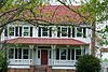 |
October 5, 1982 (#82000145) |
South of Canoochee on GA 192 32°37′55″N 82°09′59″W / 32.63208°N 82.16633°W | Canoochee | |
| 3 | Davis-Proctor House |  |
December 20, 2010 (#10001049) |
133 First Ave. 32°34′59″N 82°09′00″W / 32.58307°N 82.15013°W | Twin City | Built in 1890, is a contributing property to the Twin City Historic District |
| 4 | Albert Neal Durden House |  |
April 20, 1990 (#90000561) |
Co. Rd. 360 32°34′19″N 82°13′26″W / 32.57200°N 82.22389°W | Twin City | |
| 5 | Emanuel County Courthouse and Sheriff Department | 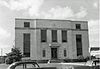 |
June 14, 1995 (#95000715) |
Main St. 32°35′49″N 82°20′05″W / 32.59685°N 82.3347°W | Swainsboro | Demolished |
| 6 | First Methodist Episcopal Church |  |
February 12, 1999 (#99000160) |
Junction of Third Ave. and Third St. 32°26′29″N 82°12′50″W / 32.44127°N 82.21375°W | Stillmore | |
| 7 | John Rountree Log House | 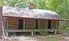 |
August 15, 1997 (#97000841) |
Junction of U.S. Route 80 and GA 192 32°35′02″N 82°09′55″W / 32.58399°N 82.16531°W | Twin City | A Place in Peril as of 2017. Local website |
| 8 | Swainsboro Light and Water Plant |  |
October 27, 2004 (#04001184) |
Bounded by East Moring and South Coleman Sts. and the Norfolk Southern Railway 32°35′48″N 82°19′52″W / 32.59665°N 82.33111°W | Swainsboro | Built in 1921 |
| 9 | Twin City Historic District |  |
February 8, 2014 (#13001168) |
6th, Railroad & 5th Aves., Maple & College Sts. 32°35′01″N 82°09′02″W / 32.583486°N 82.150577°W | Twin City |

References[]
- ^ National Park Service, United States Department of the Interior, "National Register of Historic Places: Weekly List Actions", retrieved January 28, 2022.
- ^ Numbers represent an alphabetical ordering by significant words. Various colorings, defined here, differentiate National Historic Landmarks and historic districts from other NRHP buildings, structures, sites or objects.
- ^ The eight-digit number below each date is the number assigned to each location in the National Register Information System database, which can be viewed by clicking the number.
| Wikimedia Commons has media related to National Register of Historic Places in Emanuel County, Georgia. |
Categories:
- Lists of National Register of Historic Places in Georgia (U.S. state) by county
- Buildings and structures in Emanuel County, Georgia
- National Register of Historic Places in Emanuel County, Georgia