National Register of Historic Places listings in Henry County, Georgia
This is a list of properties and districts in Henry County, Georgia that are listed on the National Register of Historic Places (NRHP).
- This National Park Service list is complete through NPS recent listings posted January 28, 2022.[1]

Current listings[]
| [2] | Name on the Register | Image | Date listed[3] | Location | City or town | Description |
|---|---|---|---|---|---|---|
| 1 | Brown House |  |
August 1, 1991 (#91000908) |
71 Macon St. 33°26′44″N 84°08′48″W / 33.445556°N 84.146667°W | McDonough | Also part of the McDonough Historic District, it now houses the Genealogical Society and Family Research Library |
| 2 | April 1, 1980 (#80001091) |
Northwest of Hampton at U.S. Routes 19/41 and Talmadge Rd. 33°25′44″N 84°19′42″W / 33.428889°N 84.328333°W | Hampton | On private property with a gated road; also known as Lovejoy Plantation; was owned by Gov. & Sen. Herman Talmadge | ||
| 3 | Globe Hotel |  |
September 5, 1985 (#85001980) |
20 Jonesboro St. 33°26′51″N 84°08′53″W / 33.4475°N 84.148056°W | McDonough | Also part of the McDonough Historic District, now houses Scarlett's Retreat Day Spa |
| 4 |  |
December 19, 1985 (#85003225) |
Off Wynn Dr. northeast of State Route 20 33°23′57″N 84°16′01″W / 33.3992°N 84.26686°W | Hampton | ||
| 5 | Hampton Depot |  |
September 10, 1979 (#79000730) |
E. Main St. 33°23′04″N 84°17′00″W / 33.384444°N 84.283333°W | Hampton | |
| 6 | October 27, 2004 (#04001180) |
10 James St. 33°23′09″N 84°16′55″W / 33.38583°N 84.28197°W | Hampton | |||
| 7 | Henry County Courthouse |  |
September 18, 1980 (#80001092) |
Courthouse Sq. 33°26′52″N 84°08′48″W / 33.44786°N 84.14674°W | McDonough | A contributor to the McDonough Historic District |
| 8 |  |
May 20, 2009 (#09000327) |
115 Atlanta St. 33°27′04″N 84°08′49″W / 33.45107°N 84.14690°W | McDonough | Currently a local law office. | |
| 9 | Lawrenceville Street Historic District |  |
February 20, 2009 (#09000054) |
Lawrenceville St., roughly between the Henry County Courthouse square and State Route 20 33°27′00″N 84°08′42″W / 33.45°N 84.145°W | McDonough | |
| 10 | Locust Grove Historic District | 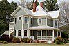 |
July 18, 2016 (#16000451) |
Centered along GA 42/US 23 between Hi-Hope Dr. & Grove Rd. 33°20′51″N 84°06′35″W / 33.347424°N 84.109793°W | Locust Grove | |
| 11 | Locust Grove Institute Academic Building |  |
September 4, 1986 (#86002179) |
3644 State Route 42//US 23 33°21′07″N 84°06′50″W / 33.35203°N 84.11402°W | Locust Grove | Now city hall |
| 12 | McDonough Historic District |  |
November 19, 2007 (#07001201) |
Centered on Griffin St. and Keys Ferry St. 33°26′49″N 84°08′50″W / 33.447°N 84.147333°W | McDonough | The pictured gas station currently houses the McDonough Welcome Center, Main Street Program and McDonough Hospitality and Tourism, Inc Office |
| 13 | 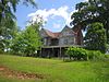 |
April 9, 1980 (#80001093) |
State Route 42/US 23 and Ward St. 33°32′40″N 84°13′58″W / 33.544444°N 84.232778°W | Stockbridge | Last two-story Victorian house in Stockbridge. Demolished in 2006. |

References[]
- ^ National Park Service, United States Department of the Interior, "National Register of Historic Places: Weekly List Actions", retrieved January 28, 2022.
- ^ Numbers represent an alphabetical ordering by significant words. Various colorings, defined here, differentiate National Historic Landmarks and historic districts from other NRHP buildings, structures, sites or objects.
- ^ The eight-digit number below each date is the number assigned to each location in the National Register Information System database, which can be viewed by clicking the number.
| Wikimedia Commons has media related to National Register of Historic Places in Henry County, Georgia. |
Categories:
- Lists of National Register of Historic Places in Georgia (U.S. state) by county
- Buildings and structures in Henry County, Georgia
- National Register of Historic Places in Henry County, Georgia