Nercillac
show This article may be expanded with text translated from the corresponding article in French. (September 2012) Click [show] for important translation instructions. |
Nercillac | |
|---|---|
 Town hall | |
 Coat of arms | |
show Location of Nercillac | |
 Nercillac | |
| Coordinates: 45°42′58″N 0°14′42″W / 45.7161°N 0.245°WCoordinates: 45°42′58″N 0°14′42″W / 45.7161°N 0.245°W | |
| Country | France |
| Region | Nouvelle-Aquitaine |
| Department | Charente |
| Arrondissement | Cognac |
| Canton | Jarnac |
| Government | |
| • Mayor (2020–2026) | Bernard Dupont[1] |
| Area 1 | 16.35 km2 (6.31 sq mi) |
| Population (Jan. 2018)[2] | 1,064 |
| • Density | 65/km2 (170/sq mi) |
| Time zone | UTC+01:00 (CET) |
| • Summer (DST) | UTC+02:00 (CEST) |
| INSEE/Postal code | 16243 /16200 |
| Elevation | 8–34 m (26–112 ft) (avg. 29 m or 95 ft) |
| 1 French Land Register data, which excludes lakes, ponds, glaciers > 1 km2 (0.386 sq mi or 247 acres) and river estuaries. | |


Nercillac (French pronunciation: [nɛʁsijak]) is a commune in the Charente department in southwestern France.
History[]
Pot shards and tegulae in Varaize near the edge of Soloire are signs of Gallo-Roman populations. Le Cluniac priory of Notre Dame located in Montour was founded in the eleventh century by the lords of Cognac and redesigned in the fifteenth century. It has been the object of pilgrimages until the Revolution, when it was sold to an individual. It was destroyed in the twentieth century. The lords lived in the home of Tignoux. Count Nercillac emigrated and returned after the restoration.
Population[]
|
|
Gallery[]
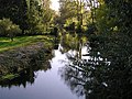
Soloire river

School and town hall
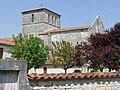
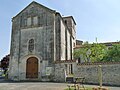
Nercillac church

Building behind the church

Fritillary guinea


See also[]
References[]
- ^ "Répertoire national des élus: les maires". data.gouv.fr, Plateforme ouverte des données publiques françaises (in French). 2 December 2020.
- ^ "Populations légales 2018". INSEE. 28 December 2020.
| Wikimedia Commons has media related to Nercillac. |
This Charente geographical article is a stub. You can help Wikipedia by . |
- Communes of Charente
- Charente geography stubs