Olongapo
Olongapo
Gapo | |
|---|---|
Highly urbanized city | |
| City of Olongapo | |
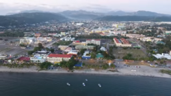 Olongapo and Subic Bay Freeport Zone Skyline | |
 Seal | |
| Nickname(s): | |
| Motto(s): Transparency and Good Governance[3] | |
| Anthem: Himno ng Olongapo (Hymn of Olongapo) | |
 Map of Central Luzon with Olongapo highlighted | |
show OpenStreetMap | |
 Olongapo Location within the Philippines | |
| Coordinates: 14°50′N 120°17′E / 14.83°N 120.28°ECoordinates: 14°50′N 120°17′E / 14.83°N 120.28°E | |
| Country | Philippines |
| Region | Central Luzon |
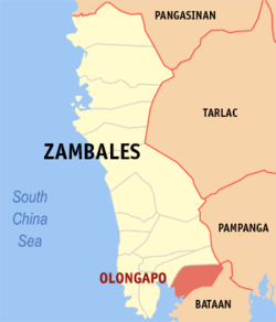
| Province | Zambales (geographically only) |
| District | 1st district |
| Founded | 4 November 1750 |
| Cityhood | 1 June 1966[4] |
| Highly Urbanized City | 7 December 1983 |
| Barangays | 17 (see Barangays) |
| Government | |
| • Type | Sangguniang Panlungsod |
| • Mayor | Rolen C. Paulino, Jr. |
| • Vice Mayor | Aquilino Y. Cortez Jr. |
| • Representative | Jeffrey D. Khonghun |
| • City Council | show
Members |
| • Electorate | 126,821 voters (2019) |
| Area | |
| • City | 185.00 km2 (71.43 sq mi) |
| • Metro | 472.16 km2 (182.30 sq mi) |
| Elevation | 193 m (633 ft) |
| Highest elevation | 1,281 m (4,203 ft) |
| Lowest elevation | 0 m (0 ft) |
| Population (2020 census) [7] | |
| • City | 260,317 |
| • Density | 1,400/km2 (3,600/sq mi) |
| • Metro | 337,811 |
| • Metro density | 720/km2 (1,900/sq mi) |
| • Households | 55,265 |
| Demonym(s) | Olongapeño (masculine) Olongapeña (Feminine) Olongapenean |
| Economy | |
| • Income class | 1st city income class |
| • Poverty incidence | 11.62% (2015)[8] |
| • Revenue | ₱1,187,106,713.41 (2016) |
| Service provider | |
| • Electricity | Olongapo Electricity Distribution Company (OEDC) |
| ZIP code | 2200 |
| PSGC | |
| IDD : area code | +63 (0)47 |
| Climate type | tropical monsoon climate |
| Native languages | Tagalog Ilocano Sambal Kapampangan Ambala |
| Website | www |


Olongapo, officially the City of Olongapo (Tagalog: Lungsod ng Olongapo; Ilocano: Siudad ti Olongapo; Sambal: Siyodad nin Olongapo; Kapampangan: Lakanbalen ning Olongapo; Pangasinan: Siyudad na Olongapo), is a 1st class highly urbanized city in the Central Luzon region of the Philippines. Located in the province of Zambales but governed independently from the province, it has a population of 260,317 people according to the 2020 census. [7]
Along with the municipality of Subic (and later, Castillejos and San Antonio as well as the municipalities of Dinalupihan, Hermosa and Morong in Bataan), it comprises Metro Olongapo, one of the twelve metropolitan areas in the Philippines.[9]
History[]
British period[]
Britain ruled the Philippines for a short time, from 1762 to 1764. The British invasion of the Philippines was the first challenge to Spain's control of the archipelago after 191 years of rule. The Royal Navy and British Army joined with the East India Company in Madras to capture Spain's Asian colony. In conjunction with the attack against Spain's key possession in the Americas, Havana, both settlements were successfully seized. However, in the Philippines, whilst the expedition was launched as part of a plan to harass the Spaniards in their possessions, as well as for commercial gain and new territories, the military campaign led by General William Draper and Admiral Samuel Cornish, may have been launched under the guise of an invasion in order to gain prize money. The publication "When Britain Ruled the Philippines 1762–1764" describes the events as they unfolded at the Admiralty in London and at the East India Company in Madras, leading to the invasion and occupation of the capital city of Manila and the port city of Cavite. The capital was looted, a galleon was seized, and the British commanders imposed a ransom of four million dollars upon the Spaniards. The enormous sums in prize money and valuables seized mainly benefited the commanders.
Spanish period[]
In 1868, a Spanish military expedition was dispatched to study the possibility of relocating the Cavite Naval Station in Subic Bay due to its unhealthy condition.
Spanish King Alfonso XII through a Royal Decree made Subic Bay (then called Subig) as Spain's stronghold in the Far East in 1884. Vice Admiral Juan Bautista de Antiquiera made Olongapo a settlement for the Spanish Navy.
On March 8, 1885, the Spanish Naval commission authorized construction of the Arsenal in Olongapo. The Spanish planned to make their naval station, and the village of Olongapo an island, protected against attack by rebels. The Spanish Navy Yard occupied the entire area east of the Spanish Gate. Employing Filipino labor, they did extensive dredging of the harbor and the inner basin and built a drainage canal. The canal served both to drain the swampy area around the yard and also to form a line of defense.
Within ten years, the Spaniards had erected walls and markers to fence off the arsenal. They had shops and buildings erected. The Spanish government spent almost fifteen years developing the naval station. From higher naval commands, the order was sent to fortify Grande Island at the mouth of Subic Bay with mines and cannons. But this project was hardly begun before it was overtaken by the rout of the Spanish Navy in Manila Bay by US Admiral George Dewey.[10][11][12][13]
American period[]

On May 1, 1898, the construction of the Spanish Administration Building was nearly complete when Admiral Dewey's flagship, USS Olympia, led the Asiatic Fleet into Manila Bay. A detachment of Admiral Dewey's fleet bombarded the navy yard. Eventually, after the surrender, Spain relinquished all her rights in the Philippines to the United States. This marked the end of more than three hundred years of Spanish rule over the islands.
Realizing the tremendous importance of Olongapo as a naval facility, the U.S. Navy decided to keep the base in functioning order; the President of the United States, then Theodore Roosevelt, on November 9, 1901, by executive order, reserved the waters of Subic and some of the adjacent lands for naval purposes.
The naval station was widened and with the establishment of the American rule in the Philippines. American defenses in the islands were facilities left by the Spanish Navy which were taken over by the United States.
Olongapo grew in direct proportion to the growth of the naval station. More people came to live in Olongapo since the Navy offered employment. To most Filipinos during that time, it was a welcome change. The promise of a different kind of experience as shop workers and office help induced many young men to leave their farms and fishing boats to work in the Navy Yard. Others finding the lure of the sea irresistible joined the U.S. Navy.
Olongapo impressed its visitors as being one of the finest communities in the country. People passing through the town never failed to comment on its cleanliness and orderliness.[10][11]
World War II[]
When the war broke out in 1941, the old town was obliterated. Olongapo had to suffer the brunt of destruction twice.
On December 14, 1941, Japanese bombers attacked the Olongapo/Subic Bay area. Ten days later, the order was given to burn Subic Bay Naval Station and withdraw. Olongapo was set aflame by the local Filipinos in anticipation of Japanese troop arrival. The USS New York was scuttled in Subic Bay.[14] When the American forces made a last-ditch stand on the Bataan peninsula, the Naval Station was abandoned and most of its facilities were burned before the Japanese came.
In 1945, Olongapo was again bombed, shelled and burned. Joint American and Philippine Commonwealth ground troops aided the recognized guerrilla fighters in liberating Olongapo from the Japanese forces. With the exceptions of the Station Chapel (it was the Olongapo Parish Church before the war) and the Spanish Gate, none of its former landmarks withstood the sweep of the war's fury. The general headquarters between the United States Army, Philippine Commonwealth Army & Philippine Constabulary were located in Olongapo during and after World War II, and were active until 1946 after operating against the Japanese for the liberation of Central Luzon.
Reconstruction and rehabilitation[]
Shortly after the war was over, the Philippines was granted independence. Olongapo was one of the principal naval bases retained by the United States. The Navy started to rebuild the town after the hostilities ceased. Olongapo was built on a new undeveloped site a couple of miles north of its former location. The prewar town site became part of the base.
The first few years after the war were difficult for the new town, as everything in the new Olongapo was damaged. There were no electric power and no drainage system. The water supply and sanitation facilities were inadequate, and streets were unpaved.[11] Gradually, Olongapo evolved into a new community: new businesses were established, housing projects were planned and civic facilities were restored.
During the Korean War, the United States spent over US$170 million to convert the base into the homeport of the Navy's Seventh Fleet, developing the Cubi Naval Air Station as the largest United States installation of its kind in Asia. Naval authorities relocated the residence from the area of the former Public Works Center area to the intersection of what is now known as Rizal Avenue and Ramon Magsaysay Drive, and in the Barangays New Asinan and New Kalalake areas. Zoning of Olongapo was patterned after American practice where streets are constructed along straight lines. The magnitude of facilities construction in the Olongapo and Subic Bay area brought growth and prosperity to Olongapo. By 1956, migrants from nearby towns and provinces had swelled the population to 39,180.[15]
Independence and cityhood[]
Unlike the rest of the Philippines which gained independence from the United States after World War II in 1946, Olongapo was governed as a part of the United States naval reservation. The Subic Bay Naval Base commanding officer was chairman of the Olongapo town council, school board, and hospital board. Olongapo's 60,000 Filipino residents paid taxes to the United States Navy and those accused of crimes involving American servicemen were tried in US Navy courts. In July 1955, Manila mayor Arsenio Lacson announced that United States service personnel accused of crimes in Manila would be tried in Philippine courts because of United States Navy abuses of Filipinos in Olongapo. On October 23, 1959, Olongapo was placed under martial law when Robert Grant, the American owner of an Olongapo auto parts store was killed and the US Navy declined to identify or try the Naval Supply Depot sentry who shot him.[16]
Olongapo was the last piece of Philippine territory surrendered by the United States to the country in the 1950s.[11][17] On December 7, 1959, 56,000 acres of land with electrical, telephone and water utilities was relinquished to Philippine Secretary of Foreign Affairs Felixberto Serrano.[16] The first mayor appointed was civic leader Ruben Geronimo. He was later succeeded by business entrepreneur Ildefonso Arriola.
Six years later, through the efforts of Representative Ramon Magsaysay Jr.in Congress and Senator Genaro Magsaysay in the Senate, President Ferdinand Marcos signed R.A. 4645. Olongapo was reconverted to a chartered city on June 1, 1966.[4] The adjacent U.S. Naval Base Subic Bay headed by Manuel Ardonia was the largest United States Navy installation in the Pacific at the time, and employed 15,000 Filipino civilians. The base was visited by 215 ships per month as Vietnam War activity peaked in 1967. The nightclubs along Ramon Magsaysay Drive between the naval base main gate and Rizal Avenue were notoriously popular among the 4,225,000 servicemen visiting the base that year.[18] Talented Filipino musicians and singers, inexpensive San Miguel beer, attractive teenage prostitutes, erotic floor shows, Jeepney rides back to the naval base and children diving for coins tossed from the bridge over the estuarine drainage channel in front of the naval base main gate were popular amenities among the sailors.[19][20][21] Olongapo was then upgraded as a highly urbanized city on December 7, 1983.
Mount Pinatubo eruption[]

On June 15, 1991, Mount Pinatubo, 20 miles (32 kilometres) from the city, violently erupted with a force eight times greater than the May 1980 eruption of Mount St. Helens. Volcanic clouds blocked out the sun. Volcanic earthquakes and heavy muddy rain, as well as thunderstorms from a typhoon passing over Central Luzon, darkened the area for 36 hours in what would become known as "Black Saturday".[22] This caused widespread damage to the United States facility and Olongapo City.
On September 16, 1991, the Senate leaders of the Philippines did not grant an extension of the existing RP-US Military Bases Agreement between the Republic of the Philippines and the United States, thus terminating the stay of the United States military in the Philippines.
Present-day Olongapo[]

Olongapo surged to national prominence during the incumbency of Mayor Richard Gordon, who, like his father before him, was against the departure of US military forces, yet lobbied for the turnover of the facility and its conversion into a freeport in 1992. Gordon spearheaded a volunteerism strategy to return an ailing economy to prosperity after Mount Pinatubo's eruption and the withdrawal of US forces. The strategy worked across all demographics and involved a strong corps of 8,000 volunteers who protected and preserved the abandoned base facilities from poachers. Gordon complemented this with an aggressive advocacy campaign to convert the area into a protected area and industrial zone. Later, he launched an aggressive international investment promotion which resulted in the accelerating the development of a prime industrial and tourism zone in the country, the Subic Bay Freeport Zone (SBFZ).[22]
As the first chartered city and highly urbanized city in its province, Olongapo's reputation among Filipinos rose from being a "sin city" in the 1960s and 1970s into a "model city" in the 1980s, 1990s and 2000s.[17]
Geography[]
Situated at the southern entry point of Zambales and the northeastern interior of the Subic Bay area, Olongapo City lies 126 kilometres (78 mi) northwest of Manila.
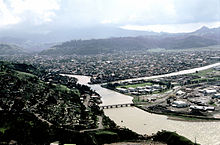
The land area of Olongapo is 103.3 square kilometres (39.9 sq mi). The city proper is located on 6.48 square kilometres (2.50 sq mi) of tidal flatland, with the rugged Zambales Mountains on its three sides, and Bataan and Subic Bay at its base. Because of this peculiar geographic location, development of city land is limited. Also, the territorial borders from nearby towns are not properly marked.[23]
Climate[]
| hideClimate data for Olongapo (weather station located in Subic, Zambales) 1992–2010, extremes recorded in Naval Air Station Cubi Point 1994–2012 | |||||||||||||
|---|---|---|---|---|---|---|---|---|---|---|---|---|---|
| Month | Jan | Feb | Mar | Apr | May | Jun | Jul | Aug | Sep | Oct | Nov | Dec | Year |
| Record high °C (°F) | 35.2 (95.4) |
38.0 (100.4) |
36.5 (97.7) |
38.2 (100.8) |
38.8 (101.8) |
37.7 (99.9) |
36.2 (97.2) |
35.0 (95.0) |
35.7 (96.3) |
35.3 (95.5) |
34.7 (94.5) |
34.4 (93.9) |
38.8 (101.8) |
| Average high °C (°F) | 31.2 (88.2) |
32.1 (89.8) |
33.5 (92.3) |
34.5 (94.1) |
33.1 (91.6) |
31.7 (89.1) |
30.9 (87.6) |
30.4 (86.7) |
30.7 (87.3) |
31.6 (88.9) |
31.7 (89.1) |
31.0 (87.8) |
31.9 (89.4) |
| Daily mean °C (°F) | 26.8 (80.2) |
27.4 (81.3) |
28.5 (83.3) |
29.6 (85.3) |
29.1 (84.4) |
28.2 (82.8) |
27.7 (81.9) |
27.4 (81.3) |
27.5 (81.5) |
27.9 (82.2) |
27.8 (82.0) |
27.1 (80.8) |
27.9 (82.2) |
| Average low °C (°F) | 22.5 (72.5) |
22.7 (72.9) |
23.6 (74.5) |
24.8 (76.6) |
25.1 (77.2) |
24.8 (76.6) |
24.4 (75.9) |
24.4 (75.9) |
24.3 (75.7) |
24.2 (75.6) |
23.9 (75.0) |
23.2 (73.8) |
24.0 (75.2) |
| Record low °C (°F) | 17.9 (64.2) |
18.7 (65.7) |
19.8 (67.6) |
21.5 (70.7) |
21.5 (70.7) |
19.0 (66.2) |
20.0 (68.0) |
21.4 (70.5) |
21.0 (69.8) |
20.6 (69.1) |
20.6 (69.1) |
18.5 (65.3) |
17.9 (64.2) |
| Average rainfall mm (inches) | 6.0 (0.24) |
4.2 (0.17) |
16.1 (0.63) |
22.5 (0.89) |
416.8 (16.41) |
385.7 (15.19) |
759.7 (29.91) |
753.5 (29.67) |
695.8 (27.39) |
214.5 (8.44) |
81.9 (3.22) |
21.9 (0.86) |
3,378.6 (133.02) |
| Average rainy days (≥ 0.1 mm) | 2 | 1 | 3 | 3 | 12 | 17 | 23 | 24 | 21 | 13 | 8 | 5 | 132 |
| Average relative humidity (%) | 67 | 66 | 65 | 65 | 73 | 78 | 81 | 81 | 82 | 77 | 73 | 68 | 73 |
| Source: PAGASA[24][25] | |||||||||||||
Olongapo has a tropical monsoon climate (Köppen climate classification: Am).[26] Temperatures are relatively cooler during the months of December, January and February, and increase slightly from March to May, which are the warmest months of the year in this part of the Philippines.
The months of December to April are extremely dry but the wet season persists for the remaining period in a year. In August, the monthly rainfall total even reaches 40.87 millimetres (1.609 inches).
The city receives an average of 3,375 millimetres (132.9 in) rainfall every year. Temperatures range from an average of around 26.3 degrees Celsius (79.3 degrees Fahrenheit) degrees in January to around 29.4 °C (84.9 °F) in April.
Barangays[]

The city is politically subdivided into 17 barangays. [27]
Barangay Population (2010)[28] Population (2015) Captain Asinan 3,341 3,445 Yang Elane Banicain 6,588 6,851 Ivan P. Tanega Barretto 18,840 19,340 Angelito "Gie" Baloy East Bajac-bajac 17,334 17,165 Gilbert G. Pinero East Tapinac 9,373 9,253 Dante Hondo Gordon Heights 26,086 27,874 Priscilla B. Ponge Kalaklan 12,934 13,137 Sunday P. Mostacho Mabayuan 10,323 10,622 Edwin Esposo New Cabalan 25,428 27,714 Delbert Muega New Ilalim 1,423 1,518 Gilbert P. Durago New Kababae 2,261 2,404 Ferdinand Quinto New Kalalake 9,219 9,808 Randy C. Sionzon Old Cabalan 18,259 19,274 Lester Nadong Pag-asa 5,672 6,070 Rodolfo Catalogan Santa Rita 39,793 43,632 Ermelando Anonat West Bajac-bajac 7,548 8,007 Anthony C. Deldio West Tapinac 6,756 6,926 Donald Elad Aquino
Demographics[]
| Year | Pop. | ±% p.a. |
|---|---|---|
| 1960 | 45,330 | — |
| 1970 | 107,785 | +9.04% |
| 1975 | 147,109 | +6.44% |
| 1980 | 156,430 | +1.24% |
| 1990 | 193,327 | +2.14% |
| 1995 | 179,754 | −1.35% |
| 2000 | 194,260 | +1.68% |
| 2007 | 227,270 | +2.19% |
| 2010 | 221,178 | −0.98% |
| 2015 | 233,040 | +1.00% |
| 2020 | 260,317 | +2.20% |
| Source: Philippine Statistics Authority [29] [30] [31][32] | ||
In the 2020 census, the population of Olongapo, was 260,317 people, [7] with a density of 1,400 inhabitants per square kilometre or 3,600 inhabitants per square mile.
Language[]
The city's population speaks a wide array of the nation's main languages, specifically: Tagalog, Sambal, Kapampangan, Pangasinan and Ilocano. The phenomenon of mixing native languages with English (e.g. Taglish, a mixture of Tagalog and English) is also common, especially amongst the youth. Many more languages are also spoken from other denominations of people.
Religion[]

Majority of the people of Olongapo are Roman Catholics, followed by members of the Iglesia ni Cristo. Protestants, Evangelicals, Born Again, Jehovah's Witnesses, Mormons, Members Church of God International, Nichiren Buddhism (Sokka Gakkai International), United Methodist Church, and Islam are also present.
Vicariate[]
The ten Roman Catholic Parishes of Olongapo City is grouped as the Vicariate of San Jose and is under the Roman Catholic Diocese of Iba. The Parishes are namely:
- St. Joseph Parish (1920) in Barangay East Bajac-Bajac
- St. Columban Parish (1963) in Barangay New Asinan
- Santa Rita Parish (1967) in Barangay Santa Rita
- Holy Trinity Parish (1975) in Barangay New Cabalan
- St. Anne Parish (1985) in Brgy Gordon Heights
- Immaculate Conception Parish (1986) in Barangay Barretto
- San Lorenzo Ruiz Parish (1991) in Barangay New Kalalake
- Holy Family Parish (1992) in Barangay Kalaklan
- St. Vincent de Paul Quasi-Parish in Barangay Old Cabalan
- San Roque Quasi-Parish in the Subic Bay Freeport Zone.
Local government[]

Olongapo, belonging to the 1st District of Zambales, is governed by a City Mayor designated as its Local Chief Executive and by a City Council as its Legislative body in accordance with the Local Government Code. Both the Mayor and the ten City Councilors are elected directly by the people through an election which is being held every three years.
As an Independent City from the province of Zambales, only the city government officials are voted by the residents of the city. The provincial government has no political jurisdiction over local transactions of the city government.
Mayors[]
The following is the list of all Mayors that ruled Olongapo after World War II:
Name Term Position Ruben Geronimo November 1959 – 1962 Municipal Mayor Ildefonso Arriola 1962 – 1964 Municipal Mayor James Gordon 1 January 1964 – 1 June 1966 Municipal Mayor James Gordon 1 June 1966 – 20 February 1967 City Mayor Jaime Guevarra 20 February 1967 – 1968 City Mayor Amelia (née Juico) Gordon 1 January 1968 – 30 June 1972 City Mayor Geronimo Lipumano[33] July 1972 – May 1980 City Mayor Richard Gordon 30 June 1980 – 23 April 1986 City Mayor (1st term) Teodoro Macapagal March 1986 – November 1987 OIC Mayor Teodoro Macapagal November 1987 – January 1988 OIC Mayor Richard Gordon 2 February 1988 – 13 March 1992 City Mayor (2nd term) Cynthia Cajudo 13 March 1992 – 21 March 1995 City Mayor Rexy Gregorio Cruz 22 March 1995 – 30 June 1995 City Mayor (Acting) Katherine Gordon 30 June 1995 – 30 June 2004 City Mayor James Gordon, Jr. 30 June 2004 – 30 June 2013 City Mayor Rolen Calixto Paulino Sr. 30 June 2013 – 3 September 2018 City Mayor Lugie Lipumano-Garcia 3 September 2018 – 3 March 2019 OIC Mayor Rolen Calixto Paulino Sr. 4 March 2019 – 30 June 2019 City Mayor Rolen Co Paulino Jr. 1 July 2019 – present City Mayor
Disaster Risk Reduction and Management[]
The City Disaster Risk Reduction and Management Office (known as Olongapo City DRRMO0 are government agency which umbrella to the city government and the national government such as National Disaster Risk Reduction and Management Council (NDRRMC), Department of National Defense (DND) and Department of the Interior and Local Government (DILG). This Agency have its well trained Rescue Service, have its own Fire and Rescue equipment and Emergency Response Service for any kind of disasters. it has a capability that they adopt from the American servicemen from the Former US Naval Base. the DRRMO are separated from Olongapo City Fire Station (OCFS) under the Bureau of Fire Protection (DILG-BFP) with its same capability usual to other Fire Services. The city have its Barangay Fire Services from some barangay's in Olongapo that control by the Barangay Government. usually, Barangay Fire Service was use as first responder in their respective territory and nearby areas. another Fire and Rescue Service was from the nearest Subic Bay Freeport Zone under its own Fire Department controlled by Subic Bay Metropolitan Authority with finest trained personnel and Rescue Equipment abandoned by the Americans similar to DRRMO. The Philippines Oldest Fire Truck was there and they also respond to the major notable disaster such as Mount Pinatubo Eruption in 1991, Fukushima disaster cleanup in 2011 and Typhoon Haiyan Search and Rescue operations in 2013.
Law Enforcement and Public Safety[]
This section may require cleanup to meet Wikipedia's quality standards. The specific problem is: Inconsistent tense. (February 2021) |
The city has six different police stations under control by Olongapo City Police Office (OCPO) and was umbrella to Philippine National Police (PNP). The city police main garrison was on Camp Cabal (also known in locals as "164") at Barangay Barretto. Another was the Law Enforcement Department controlled by the Subic Bay Metropolitan Authority which securing the coastal waters of Subic Bay and its nearby Freeport Zone under Republic Act 7227 (it is known as "SBMA Police").
Contrary to traffic enforcement, the city has separate law enforcement which is the Office of the Traffic Management and Public Safety (OTMPS). The office focuses on implementation of color coded transport scheme, security of government-owned establishment, organizing public market, and providing traffic enforcement safety which was mandated parallel and coordinated to Land Transportation Office. It is different to local police force and monitor on primary road network in the city.
Infrastructure[]
Transportation[]
Airport[]
There are no airport on Olongapo itself although the Subic Bay International Airport in the adjacent town of Morong, Bataan serves the general area of Olongapo. The airport is within the Subic Bay Freeport Zone and was formerly known as Naval Air Station Cubi Point, when it was still an airbase of the United States.
Sea Port[]
Olongapo is served by the Port of Subic Bay, operated and managed by the Subic Bay Metropolitan Authority. Some facilities of the seaport are located on the Olongapo portion of the Subic Freeport Zone namely the Alava, Bravo, and Rivera Wharves.
Roads[]
The city has an organized road network, featuring a series of rectangular street grids. The primary road that connects Olongapo to the rest of the other is the Jose Abad Santos Avenue. In the city's main district, the names of those streets running from North to South follow the English alphabet's order. While streets running East to West are numbered from 1st to 27th, starting from the South parallel and up. Even streets are on the East side of the city while the odd streets are on the West. Most of the roads in Olongapo are made of concrete and asphalt.
Public transportation[]

The city boasts its color-coded public transportation system which it has pioneered in the country. All public utility jeepneys and tricycles have its own color code depending on the district, zone or route that it is serving. Taxi services are also operated in the city but are limited.
Bus Terminals[]
Victory Liner and Saulog Transit are the leading bus operators having their own terminals in the city which transports people in and out of the city. Local bus terminals are also present and are primarily used for transportation in neighboring towns and inside the Subic Bay Freeport Zone.
Road infrastructure[]
Olongapo is accessible through the National Highway (via Zigzag Road) from Hermosa and Dinalupihan, Bataan. The National Highway cuts through the city center and goes through north up to Barangay Barreto and then on to the neighboring town of Subic, and the rest of the towns in Zambales up to Pangasinan province. Another access to the city is via SCTEX and Subic Freeport Expressway exiting to the gates of Subic Bay Freeport Zone and also, from the south, Morong, Bataan (via Balanga, Bataan) through the Morong gate of Subic Bay Freeport Zone.
Public Utilities[]
Electricity[]
Electricity services were formerly provided by the government-run Public Utilities Department (PUD) since the city was founded. However, in the late 2000s, the city faced debt in its electricity distribution costs amounting to P5 billion to power suppliers and threatened to cut the city from the Luzon power grid. Then Mayor James Gordon Jr. also attributed the crisis to low collection rate due to nonpayment or debts incurred by consumers, widespread energy theft and corruption in the PUD. The situation worsened because of interests imposed by Private Sector Assets and Liabilities Management Corp. (PSALM), the refusal of the Energy Regulatory Commission (ERC) to grant an increase in power rates, and the years of delay in the PUD's privatization.[34]
In 2013, through Republic Act No. 10373, the PUD was sold for Php 610 million to Olongapo Electricity Distribution Company (OEDC), an affiliate of Cagayan Electric Power and Light Company (CEPALCO), which was given a 25-year franchise to take over the city's power distributor. The company has since upgraded the city's obsolete and dilapidated distribution network and has made significant improvements to the city's electricity services.[35]
Water[]
Water services are provided by Subic Water and Sewerage Company (also known as Subic Water. Not to be confused with Subic Water District (SWD), which is a different water distribution company serving the neighboring towns of Subic, Zambales.). In 2013, the city's shares in Subic Water has been sold to Maynilad Water Services Inc. (Maynilad) to continue modernizing the city's water utilities services.[36] In March 2016, this was reversed and the city has bought back its shares because the city wanted to have a representation in Subic Water because the city's constituents accounted for the majority of Subic Water's customers.
Notable people[]
- Angelee delos Reyes (b. 1987), Miss Philippines Earth 2013
- Angelu de Leon (b. 1979), actress of GMA Network
- Arnel Pineda (b. 1967), singer/lead vocalist of Journey
- Blakdyak (Joseph Amoto-Formaran) (1969–2016), singer, comedian and actor
- Eric Cray (b. 1988), track and field athlete, an Olympian at the 2016 Summer Olympics
- Freddie Aguilar (b. 1953), noted musician, singer-songwriter
- Jake Vargas (b. 1992), model and actor of GMA Network
- Liezel Lopez (b. 1997), actress, model and StarStruck contestant
- K Brosas (b. 1975), comedian, singer and host of ABS-CBN
- Kristofer Martin (b. 1994), actor of GMA Network
- Lauren Young (b. 1993), actress of GMA Network
- Megan Young (b. 1990), actress and host of GMA Network, Miss World Philippines 2013 and Miss World 2013
- Melissa Ricks (b. 1990), actress and host of ABS-CBN
- Moira Dela Torre (b. 1993), singer-songwriter of ABS-CBN
- Raikko Mateo (b. 2008) child actor of ABS-CBN, who took the titular role in Honesto
- Rico Barrera (b. 1981), model and actor of ABS-CBN, Pinoy Big Brother season 1 housemate
- Simon Ibarra (b. 1960), actor, and model
- Tom Rodriguez (b. 1987) actor of GMA Network
- Willie Miller (b. 1977), basketball player
- Wowie de Guzman (b. 1976), actor of ABS-CBN
Sister cities[]
Olongapo has the following sister cities:
 Cabanatuan, Philippines
 Bremerton, Washington, United States
- National City, California, United States[37]
- Virginia Beach, Virginia, United States[38]
References[]
- ^ "AUICK Newsletter No.54 AUICK News". Asian Urban Information Center of Kobe. 2010. Archived from the original on April 14, 2019. Retrieved April 14, 2019.
The City Council of Olongapo recently passed an ordinance adopting the title "City of Volunteers" for Olongapo City, to reflect its strong community-based volunteerism.
- ^ Songco, Pauline (August 13, 2018). "Gift of a legacy". Daily Tribune. Archived from the original on August 15, 2018. Retrieved April 14, 2019.
- ^ "Intense race to City Hall in Olongapo". The Manila Times. February 2, 2016. Archived from the original on July 11, 2018. Retrieved April 14, 2019.
Paulino, on the other hand, is banking on his growing popularity as a friendly, easy to approach city mayor and his slogan “Transparency and Good Governance” to extend his stay as the city’s chief executive.
- ^ Jump up to: a b "Olongapo City – Brief History".
- ^ City of Olongapo | (DILG)
- ^ "2015 Census of Population, Report No. 3 – Population, Land Area, and Population Density" (PDF). Philippine Statistics Authority. Quezon City, Philippines. August 2016. ISSN 0117-1453. Archived (PDF) from the original on May 25, 2021. Retrieved July 16, 2021.
- ^ Jump up to: a b c Census of Population (2020). "Region III (Central Luzon)". Total Population by Province, City, Municipality and Barangay. PSA. Retrieved July 8, 2021.
- ^ https://psa.gov.ph/sites/default/files/City%20and%20Municipal-level%20Small%20Area%20Poverty%20Estimates_%202009%2C%202012%20and%202015_0.xlsx; publication date: 10 July 2019; publisher: Philippine Statistics Authority.
- ^ "Building Globally Competitive Metro Areas in the Philippines" (PDF). Archived from the original (PDF) on October 4, 2013.
- ^ Jump up to: a b "History of Subic Bay and Olongapo City". Archived from the original on March 13, 2012. Retrieved December 13, 2011.
- ^ Jump up to: a b c d "The Olongapo Story".
- ^ "Olongapo City Barangay and History".
- ^ "History of Olongapo City".
- ^ Subic Bay History – 1940's. Subicbaypi.com (April 8, 1942). Retrieved on 2013-07-28.
- ^ "World War II – Olongapo City Official Website".
- ^ Jump up to: a b Anderson, Gerald Subic Bay from Magellan to Pinatubo: The History of the U.S. Naval Station Subic Bay Gerald Anderson (2009) ISBN 1441444521 pp.130–138
- ^ Jump up to: a b "World Bank – Olongapo Profile" (PDF).
- ^ Tucker, Spencer C. The Encyclopedia of the Vietnam War: A Political, Social, and Military History (2011) ISBN 1851099611 p.863
- ^ Sherwood, John Afterburner: Naval Aviators and the Vietnam War NYU Press (2004) ISBN 081479842X pp.27–28
- ^ "LIBERTY CALL: Olongapo City". Dennis Clevenger. Retrieved August 3, 2012.
- ^ "Olongapo". Dave Payson. Retrieved August 3, 2012.
- ^ Jump up to: a b "Twin Disasters- Olongapo City Official Website".
- ^ "Philippines Travel and Hotel Guide".
- ^ "Subic, Zambales Climatological Normal Values". Philippine Atmospheric, Geophysical and Astronomical Services Administration. Archived from the original on October 18, 2018. Retrieved October 18, 2018.
- ^ "Cubi Point Subic, Olongapo Climatological Extremes". Philippine Atmospheric, Geophysical and Astronomical Services Administration. Archived from the original on October 18, 2018. Retrieved October 18, 2018.
- ^ "Average Weather For Subic Bay Freeport Zone, Philippines". Retrieved May 11, 2013.
- ^ "Province: Zambales". PSGC Interactive. Quezon City, Philippines: Philippine Statistics Authority. Retrieved November 12, 2016.
- ^ "Total Population by Province, City, Municipality and Barangay: as of May 1, 2010" (PDF). 2010 Census of Population and Housing. Philippine Statistics Authority. Archived from the original (PDF) on November 15, 2012. Retrieved February 15, 2013.
- ^ Census of Population (2015). "Region III (Central Luzon)". Total Population by Province, City, Municipality and Barangay. PSA. Retrieved June 20, 2016.
- ^ Census of Population and Housing (2010). "Region III (Central Luzon)". Total Population by Province, City, Municipality and Barangay. NSO. Retrieved June 29, 2016.
- ^ Censuses of Population (1903–2007). "Region III (Central Luzon)". Table 1. Population Enumerated in Various Censuses by Province/Highly Urbanized City: 1903 to 2007. NSO.
- ^ "Province of Zambales". Municipality Population Data. Local Water Utilities Administration Research Division. Retrieved December 17, 2016.
- ^ Sison, Bebot (May 17, 2013). "Gordons lose; Payumos fall in Bataan". The Philippine Star. Retrieved August 21, 2014.
The only other time that a Gordon was defeated in an election was in 1970 when Geronimo Lipumano won by a landslide against the late Amelia Gordon, the mother of Dick Gordon.
"1974MANILA07373_b". Public Library of US Diplomacy. Wikileaks. June 20, 1974. Retrieved August 21, 2014. - ^ Gonzaga, Robert. "Olongapo's power debt burden". Philippine Daily Inquirer. Retrieved July 3, 2016.
- ^ "Aquino signs law on Olongapo power privatization". Philippine Daily Inquirer. Retrieved July 3, 2016.
- ^ "Olongapo sells 10% of Subic Water to Maynilad". Rappler. Retrieved July 3, 2016.
- ^ City Council and Community Development Commission of National City, CA. "MINUTES OF THE REGULAR MEETING OF THE CITY COUNCIL AND COMMUNITY DEVELOPMENT COMMISSION OF NATIONAL CITY, CALIFORNIA". Retrieved December 17, 2016.
- ^ "Sister Cities Association of Virginia Beach". Sister Cities Association of Virginia Beach. Retrieved March 31, 2016.
External links[]
| Wikivoyage has a travel guide for Olongapo. |
| Wikimedia Commons has media related to Olongapo. |
- Philippine Standard Geographic Code
- Olongapo City City Council
- Olongapo City Officials and Government Offices Telephone Directory
| show Places adjacent to Olongapo |
|---|
| show Articles Related to Olongapo |
|---|

| show Authority control |
|---|
- Olongapo
- Cities in Central Luzon
- Populated places in Zambales
- Port cities and towns in the Philippines
- Highly urbanized cities in the Philippines
- Populated places established in 1750
- 1750 establishments in the Philippines