Olti Okrug
Olti Okrug
Ольтинский округ | |
|---|---|
 | |
 | |
| Country | Russian Empire |
| Oblast | Kars |
| Viceroyalty | Caucasus |
| Established | 1878 |
| Abolished | 1918 |
| Seat | Olti |
| Uchastoks | Olti, and Tausker |
| Area | |
| • Total | 2,983 km2 (1,152 sq mi) |
| Population (1916) | |
| • Total | 40,091 |
| • Density | 13/km2 (35/sq mi) |
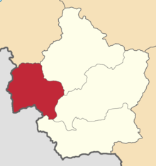
The Olti Okrug (Russian: Ольтинский округ; Armenian: Օլթիի գավառ; Georgian: ოლთისის ოკრუგი) was one of the four okrugs of the Kars Oblast of the Russian Empire, existing between 1878 and 1918. Its capital was the town of Olti, presently part of the Erzurum Province of the Republic of Turkey. The okrug bordered with the Kars Okrug to the southeast, the Ardahan Okrug in the northwest, the Kagizman Okrug to its immediate south, the Batum Oblast in the north, and the Erzurum Vilayet of the Ottoman Empire in the west.
History[]
The Olti Okrug was one of the four territorial administrative subunits (counties) of the Kars Oblast created after its annexation into the Russian Empire in 1878 through the Treaty of San Stefano, following the defeat of the Ottoman Empire.[1]
During the First World War, the Kars Oblast became the site of intense battles between the Russian Caucasus Army supplemented by Armenian volunteers and the Ottoman Third Army, the latter of whom was successful in briefly occupying Ardahan on 25 December 1914 before they were dislodged in early January 1915.
On 3 March 1918, in the aftermath of the October Revolution the Russian SFSR ceded the entire Kars Oblast including the Olti Okrug through the Treaty of Brest-Litovsk to the Ottoman Empire, who had been unreconciled with its loss of the territory since 1878. Despite the ineffectual resistance of the Transcaucasian Democratic Federative Republic which had initially rejected the aforementioned treaty, the Ottoman Third Army was successful in occupying the Kars Oblast and expelling its 100,000 panic-stricken Armenian inhabitants.[2]
The Ottoman Ninth Army under the command of Yakub Shevki Pasha, the occupying force of the district by the time of the Mudros Armistice, were permitted to winter in Kars until early 1919, after which on 7 January 1919 Major General G.T. Forestier-Walker ordered their complete withdrawal to the pre-1914 Ottoman-frontier. Intended to hinder the westward expansion of the fledgling Armenian and Georgian republics into the Kars Oblast, Yukub Shevki backed the emergence of the short-lived South-West Caucasus Republic with moral support, also furnishing it with weapons, ammunition and instructors.[3]
The South-West Caucasus Republic administered the Olti Okrug and neighboring formerly occupied districts for three months before provoking British intervention by order of General G.F. Milne, leading to its capitulation by Armenian and British forces on 10 April 1919.[4][5] Consequently, the Kars Oblast largely came under the Armenian civil governorship of Stepan Korganian who wasted no time in facilitating the repatriation of the region's exiled refugees.[6]
Despite the apparent defeat of the Ottoman Empire, Turkish agitators were reported by Armenian intelligence to have been freely roaming the countryside of Kars encouraging sedition among the Muslim villages, culminating in a series of anti-Armenian uprisings on 1 July 1919.[7]
The Kars Oblast for the third time in six years saw invading Turkish troops, this time under the command of General Kâzım Karabekir in September 1920 during the Turkish-Armenian War. The disastrous war for Armenia resulted in the permanent expulsion of the region's ethnic Armenian population, many who inexorably remained befalling massacre, resulting in the region joining the Republic of Turkey through the Treaty of Alexandropol on 3 December 1920. Turkey's annexation of Kars and the adjacent Surmalu Uyezd was confirmed in the treaties of Kars and Moscow in 1921, by virtue of the new Soviet regime in Armenia.[8]
Administrative divisions[]
The uchastoks (sub-counties) of the Olti Okrug were:
- Olti (Ольтинский участок)
- Tausker (Таускерский округ)
Demographics[]
Caucasian Calendar of 1915[]
The 1915 Caucasian Calendar which produced statistics of 1914 indicates 40,091 residents in the Olti Okrug, including 20,540 men and 19,551 women, 37,553 of whom were the permanent population, and 2,538 were temporary residents. The statistics indicated the town Olti to be overwhelmingly ethnic Armenian in population with a sizeable Turkish minority, conversely, the rest of the okrug was mainly Turkish, with sizeable Kurdish, Georgian, Greek and Armenian minorities:[9]
| Area | Russians | Georgians | Armenians | North Caucasians | Kurds | Other Asian Nationalities | Gypsies | Jews | TOTAL | ||||
|---|---|---|---|---|---|---|---|---|---|---|---|---|---|
| Orthodox | Sectarian | Muslim | Yezidi | Christian[a] | Shia Muslim | Sunni Muslim[b] | |||||||
| Olti | 159 | 18 | 78 | 2,188 | 63 | 51 | 51 | ... | 58 | 458 | 134 | ... | 3,258 |
| Rural | 24 | ... | 4,017 | 2,765 | 61 | 5,128 | ... | 3,454 | 3 | 21,309 | ... | 72 | 36,833 |
| TOTAL | 183 | 18 | 4,095[c] | 4,953 | 124 | 5,179 | 51 | 3,454 | 61 | 21,767 | 134 | 72 | 40,091 |
| 0.5% | 0.0% | 10.2% | 12.4% | 0.3% | 12.9% | 0.1% | 8.6% | 0.2% | 54.3% | 0.3% | 0.2% | 100.0% | |
Notes[]
References[]
- ^ "КАРССКАЯ ОБЛАСТЬ — информация на портале Энциклопедия Всемирная история". w.histrf.ru. Retrieved 2021-12-05.
- ^ Hovannisian, Richard G. (1971–1996). The Republic of Armenia. Berkeley: University of California Press. p. 27. ISBN 0-520-01805-2. OCLC 238471.
- ^ Hovannisian, Richard G. (1971–1996). The Republic of Armenia. Berkeley: University of California Press. p. 201. ISBN 0-520-01805-2. OCLC 238471.
- ^ Andersen, Andrew. "Armenia in the Aftermath of Mudros: Conflicting claims and Strife with the Neighbors".
{{cite web}}: CS1 maint: url-status (link) - ^ Hovannisian, Richard G. (1971–1996). The Republic of Armenia. Berkeley: University of California Press. p. 220. ISBN 0-520-01805-2. OCLC 238471.
- ^ Hovannisian, Richard G. (1971–1996). The Republic of Armenia. Berkeley: University of California Press. p. 204. ISBN 0-520-01805-2. OCLC 238471.
- ^ Hovannisian, Richard G. (1971–1996). The Republic of Armenia. Berkeley: University of California Press. p. 66. ISBN 0-520-01805-2. OCLC 238471.
- ^ De Waal, Thomas (2015). Great catastrophe : Armenians and Turks in the shadow of genocide. Oxford. p. 86. ISBN 978-0-19-935070-4. OCLC 897378977.
- ^ Кавказский календарь .... на 1917 год (in Russian). pp. 359–360.
Further reading[]

- Kars Oblast
- Caucasus Viceroyalty (1801–1917)
- Governorates of the Caucasus
- History of Ardahan Province
- History of Erzurum Province
- History of Kars Province
- Modern history of Armenia
- States and territories established in 1878
- States and territories disestablished in 1917
- 1878 establishments in the Russian Empire
- 1917 disestablishments in Russia
- Soviet Union–Turkey relations