Patton Township, Ford County, Illinois
Patton Township | |
|---|---|
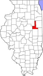
 Location in Ford County | |
 Ford County's location in Illinois | |
| Coordinates: 40°26′47″N 88°08′23″W / 40.44639°N 88.13972°WCoordinates: 40°26′47″N 88°08′23″W / 40.44639°N 88.13972°W | |
| Country | United States |
| State | Illinois |
| County | Ford |
| Established | November 6, 1860 |
| Area | |
| • Total | 61.37 sq mi (158.9 km2) |
| • Land | 61.28 sq mi (158.7 km2) |
| • Water | 0.08 sq mi (0.2 km2) 0.13% |
| Elevation | 761 ft (232 m) |
| Population (2010) | |
| • Estimate (2016)[1] | 5,132 |
| • Density | 87.4/sq mi (33.7/km2) |
| Time zone | UTC-6 (CST) |
| • Summer (DST) | UTC-5 (CDT) |
| ZIP codes | 60949, 60957 |
| FIPS code | 17-053-58122 |
Patton Township is located in Ford County, Illinois. As of the 2010 census, its population was 5,358 and it contained 2,304 housing units.[2] It was named Prairie City Township when established as a township in Vermilion County; its name was changed to Patton Township on September 14, 1857.
Geography[]
According to the 2010 census, the township has a total area of 61.37 square miles (158.9 km2), of which 61.28 square miles (158.7 km2) (or 99.85%) is land and 0.08 square miles (0.21 km2) (or 0.13%) is water.[2]
Paxton[]
Paxton, the county seat, is the largest town in Patton Township.
Perdueville[]
Perdueville is an unincorporated area in section 9 of Patton township. Extant structures include a grain elevator which is still in service next to the rail grade, now removed. The Perdueville Pheasant Habitat Area is located in section 32 of the township.[3] The habitat area was purchased in 1995 and consists of 122 acres (0.49 km2).[4]

Ten Mile Grove[]
Ten Mile Grove is said to be the earliest settlement in Patton Township with about a dozen families residing there in 1853. It was located on the Danville-Ottawa road and named such because it was ten miles (16 km) from the nearest settlement.[5] The grove is partly contained in the Howard Thomas Memorial Nature Preserve. The preserve, containing many Bur oak, sustained damage in a 2004 wind storm which felled numerous trees. Thirty to fifty percent of trees were felled in some portions, especially the western part. Volunteers cleared trees from the trails, one of which had 17 trees blocking it.[6]

Cemeteries[]
The township contains these seven cemeteries: Farmersville, Glen, Hall, Meharry, Pells Park, Prospect and Ten Mile Grove.
Major highways[]
 Interstate 57
 US Route 45
 Illinois Route 9
Airports and landing strips[]
- C D Maulding Airport
- Clifford D Foster Airport
- Paxton Airport
Demographics[]
| Historical population | |||
|---|---|---|---|
| Census | Pop. | %± | |
| 2016 (est.) | 5,132 | [1] | |
| U.S. Decennial Census[7] | |||
School districts[]
- Paxton-Buckley-Loda Community Unit School District 10
Political districts[]
- Illinois' 15th congressional district
- State House District 105
- State Senate District 53
References[]
- "Patton Township, Ford County, Illinois". Geographic Names Information System. United States Geological Survey. Retrieved 2010-01-16.
- United States Census Bureau 2007 TIGER/Line Shapefiles
- United States National Atlas
- ^ a b "Population and Housing Unit Estimates". Retrieved June 9, 2017.
- ^ a b "Population, Housing Units, Area, and Density: 2010 - County -- County Subdivision and Place -- 2010 Census Summary File 1". United States Census. Archived from the original on 2020-02-12. Retrieved 2013-05-28.
- ^ Perdueville Habitat Area Hunter Fact Sheet Archived 2008-03-27 at the Wayback Machine
- ^ Chicago Sun-Times. Rainy and gray -- perfect day: Hunting in Pheasant Habitat Area.
- ^ The Pantagraph. Landmark barn to be restored; Foundation helps project in area of Ten Mile Grove. April 18, 2005.
- ^ The Pantagraph. (Bloomington, Illinois) Grove's return came naturally. January 30, 2006.
- ^ "Census of Population and Housing". Census.gov. Retrieved June 4, 2016.
External links[]
- Townships in Ford County, Illinois
- Townships in Illinois

