Point La Nim, New Brunswick
Point La Nim | |
|---|---|
 Point La Nim Location within New Brunswick. | |
| Coordinates: 48°04′N 66°27′W / 48.06°N 66.45°WCoordinates: 48°04′N 66°27′W / 48.06°N 66.45°W | |
| Country | |
| Province | |
| County | Restigouche |
| Parish | Dalhousie |
| Electoral Districts Federal | Madawaska—Restigouche |
| Provincial | Campbellton-Dalhousie |
| Government | |
| • Type | Local service district |
| • MP | René Arseneault (Lib.) |
| • MLA | Guy Arseneault (Lib.) |
| Area | |
| • Land | 10.91 km2 (4.21 sq mi) |
| Population (2016) | |
| • Total | 231 |
| • Density | 21.17/km2 (54.8/sq mi) |
| • Pop 2011-2016 | |
| • Dwellings | 130 |
| Time zone | UTC-4 (AST) |
| • Summer (DST) | UTC-3 (ADT) |
| Postal code(s) | E3N |
| Area code(s) | 506 |
| Access Routes | |
| Median Income* | $57,472 CDN |
| |

Point La Nim (2016 pop. 231) is an unincorporated community in Restigouche County, New Brunswick, Canada.[1][2]
The community is located on the Restigouche River immediately upstream (west) from the town of Dalhousie. Its name was taken from Mi'kmaq name "ananimkik" which translates to "lookout place". Located west of Dalhousie. Point La Nim's post office was originally called "Point La Nin" in 1855. It was renamed Point La Nim in 1862.
History[]
Notable people[]
See also[]
References[]
- ^ New Brunswick Provincial Archives - Point La Nim
- ^ "Point La Nim, LSD [Designated place], New Brunswick and New Brunswick [Province]". Statistics Canada. November 29, 2017. Retrieved June 9, 2019.

Point La Nim / Restigouche River - summer
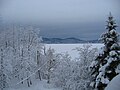
Point La Nim / Restigouche River - winter


Places adjacent to Point La Nim, New Brunswick | ||||||||||||||||
|---|---|---|---|---|---|---|---|---|---|---|---|---|---|---|---|---|
| ||||||||||||||||
This New Brunswick location article is a stub. You can help Wikipedia by . |
Categories:
- Communities in Restigouche County, New Brunswick
- Designated places in New Brunswick
- Local service districts of Restigouche County, New Brunswick
- New Brunswick geography stubs