Pont-de-Labeaume
show This article may be expanded with text translated from the corresponding article in French. (December 2008) Click [show] for important translation instructions. |
Pont-de-Labeaume | |
|---|---|
Commune | |
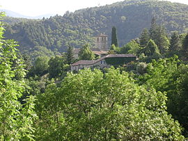 The church of Niègles, in Pont-de-Labeaume | |
show Location of Pont-de-Labeaume | |
 Pont-de-Labeaume | |
| Coordinates: 44°40′00″N 4°17′23″E / 44.6667°N 4.2897°ECoordinates: 44°40′00″N 4°17′23″E / 44.6667°N 4.2897°E | |
| Country | France |
| Region | Auvergne-Rhône-Alpes |
| Department | Ardèche |
| Arrondissement | Largentière |
| Canton | Haute-Ardèche |
| Government | |
| • Mayor (2020–2026) | Yves Veyrenc[1] |
| Area 1 | 4.66 km2 (1.80 sq mi) |
| Population (Jan. 2018)[2] | 571 |
| • Density | 120/km2 (320/sq mi) |
| Time zone | UTC+01:00 (CET) |
| • Summer (DST) | UTC+02:00 (CEST) |
| INSEE/Postal code | 07178 /07380 |
| Elevation | 256–586 m (840–1,923 ft) (avg. 304 m or 997 ft) |
| 1 French Land Register data, which excludes lakes, ponds, glaciers > 1 km2 (0.386 sq mi or 247 acres) and river estuaries. | |


Pont-de-Labeaume (French pronunciation: [pɔ̃ də labom]; Occitan: Pònt de La Bauma) is a commune in the Ardèche department in southern France.
Geography[]
The river Lignon forms small part of the commune's western border, then joins the Ardèche, which flows east through the commune.
The village is located in the western part of the commune, on the right bank of the Ardèche.
Population[]
| Year | Pop. | ±% |
|---|---|---|
| 1962 | 465 | — |
| 1968 | 532 | +14.4% |
| 1975 | 545 | +2.4% |
| 1982 | 529 | −2.9% |
| 1990 | 517 | −2.3% |
| 1999 | 485 | −6.2% |
| 2008 | 577 | +19.0% |
See also[]
References[]
- ^ "Répertoire national des élus: les maires". data.gouv.fr, Plateforme ouverte des données publiques françaises (in French). 2 December 2020.
- ^ "Populations légales 2018". INSEE. 28 December 2020.
| Wikimedia Commons has media related to Pont-de-Labeaume. |
| show Authority control |
|---|
This Ardèche geographical article is a stub. You can help Wikipedia by . |
Categories:
- Communes of Ardèche
- Ardèche geography stubs