Sürmene
Sürmene | |
|---|---|
 Sürmene | |
| Coordinates: 40°54′51″N 40°06′45″E / 40.91417°N 40.11250°ECoordinates: 40°54′51″N 40°06′45″E / 40.91417°N 40.11250°E | |
| Country | |
| Province | Trabzon |
| Government | |
| • Mayor | Rahmi Üstün (AKP) |
| • Kaymakam | Mustafa Özarslan |
| Area | |
| • District | 226.63 km2 (87.50 sq mi) |
| Elevation | 0 m (0 ft) |
| Population (2012)[2] | |
| • Urban | 15,445 |
| • District | 26,945 |
| • District density | 120/km2 (310/sq mi) |
| Climate | Cfa |
| Website | www.surmene.bel.tr |


Sürmene (Greek: Σούρμενα, Sourmena; Ottoman Turkish: ﺳﻮرﻣﻨﻪ, romanized as Sürmena[/e]) is a town and a district of Trabzon Province in the Black Sea region of Turkey. In ancient times nearby was the town of Hyssus or Hyssos (Ancient Greek: Υσσός) and Issiporto.[3]
| Wikimedia Commons has media related to Sürmene. |
The mayor is Rahmi Üstün (AKP).
The little town of Sürmene (Hamurgan) is situated some 40 km (25 mi) east of Trabzon. Known in antiquity also as Susarmia or Augustopolis,[citation needed] it lies on the River Kora ( Deresi) and is best known as the place where Xenophon and his Ten Thousand fell sick after eating wild honey, an event which was confirmed by the local people. In the village of Sürmene , 5 km (3.1 mi) to the west of Sürmene, stands a ruined medieval castle as well as the impressive 18th century mansion (Derebeyli Kale). It was formerly the seat of the Yakupoğlu family, who lived here as rulers (derebey) of the surrounding region relatively free of interference from the Sublime Porte in Istanbul.
Economy[]
Historically, Sürmene had produced small amounts of manganese. The area also had mineral springs, and shipped bottled water to Istanbul.[4]
Education[]
Surmene county has had a lot educational institution since the first years of the Republic. As of today, Sürmene has a faculty (Surmene KTU Faculty of Marine Sciences), five vocational high schools, a high school and an Anatolian high school. In addition, there are many primary schools in the county. Also there is a student dormitory for university students' shelter in the county.
Social life[]
Surmene is one of the towns which have managed to become the leader of the Eastern Black Sea in terms of social life. In the years when the population number reached ten thousands there were 2 long-serving cinemas. Also before the construction of the Black Sea Coastal Road especially in summer months there had been a vivid social life. At that time the dynamism in the streets used to last to 02:00 a.m and the town used to present a vivid turism center. The extreme settlement which began in the year of 1955 caused the town to face with the same problem of the large cities: ‘’unplanned urbanization’’. And the same problem exist today. And also in long terms of construction, people living away from home got disturbed by the construction sounds and they gave up coming back to their homelands and this led to a downfall in the tourism receipts. In this context, the population of the town which is 13.000 today, it can not grow a significant rise in the summer moths. There are several sports club operating in various branches and a folk association. And also Sürmene Beneficial Association and Sürmene Culture and Tourism Association named Istanbul centered local civil society organizations are active in Sürmene. Even though there are many elementary and middle schools there is no alumni association for these schools.
Flora and fauna[]
According to WWF The most endemic flora tourf is exist in Ağaçbaşı yayla in Surmene.[1][permanent dead link]
- Zehirli biberiye (Andromeda polifolia),
- Böcek yiyen bitkilerden Drosera,
- Pamukotu (Eriophorum angustifolium ve E. latifolium),
- Kurtayağı (Lycopodiella inundata),
- Kara ot (Rhynchospora alba)
Gallery[]

Memiş Agha Mansion in Sürmene

The Chamber of Commerce of Sürmene -It was the first chamber of commerce in Turkey
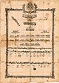
Sürmene Sekbanlardan Ahmed Agha (Diploma)

historical graveyard stone
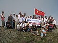
on the top of Madur mountain.

Fatih Akın Turkish film director from .
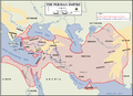
Ten Thousand's route to Sürmene

Sunset in Surmene


See also[]
- Memiş Aga Mansion
- Memiş Agha
- Madur
- Anabasis (Xenophon)
- Ten Thousand
- Sürmene knife
References[]
- ^ "Area of regions (including lakes), km²". Regional Statistics Database. Turkish Statistical Institute. 2002. Retrieved 2013-03-05.
- ^ "Population of province/district centers and towns/villages by districts - 2012". Address Based Population Registration System (ABPRS) Database. Turkish Statistical Institute. Retrieved 2013-02-27.
- ^ "An Overview of Rize's History". Republic of Turkey Ministry of Culture and Tourism. Archived from the original on September 29, 2007. Retrieved 2008-04-11.
- ^ Prothero, W. G. (1920). Armenia and Kurdistan. London: H.M. Stationery Office. p. 73.
External links[]
- District governor's official website
- District municipality's official website* Surmenem.com - A local website about Sürmene
| show Sürmene in Trabzon Province of Turkey |
|---|
- Sürmene
- Populated places in Trabzon Province
- Populated coastal places in Turkey