Saint-Sulpice-de-Ruffec
show This article may be expanded with text translated from the corresponding article in French. (December 2008) Click [show] for important translation instructions. |
Saint-Sulpice-de-Ruffec | |
|---|---|
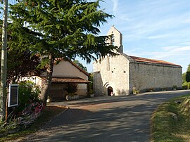 The church in Saint-Sulpice-de-Ruffec | |
show Location of Saint-Sulpice-de-Ruffec | |
 Saint-Sulpice-de-Ruffec | |
| Coordinates: 45°56′27″N 0°18′55″E / 45.9408°N 0.3153°ECoordinates: 45°56′27″N 0°18′55″E / 45.9408°N 0.3153°E | |
| Country | France |
| Region | Nouvelle-Aquitaine |
| Department | Charente |
| Arrondissement | Confolens |
| Canton | Charente-Nord |
| Intercommunality | Val de Charente |
| Government | |
| • Mayor (2020–2026) | Geoffroy Dudouit |
| Area 1 | 2.38 km2 (0.92 sq mi) |
| Population (Jan. 2018)[1] | 31 |
| • Density | 13/km2 (34/sq mi) |
| Time zone | UTC+01:00 (CET) |
| • Summer (DST) | UTC+02:00 (CEST) |
| INSEE/Postal code | 16356 /16460 |
| Elevation | 92–162 m (302–531 ft) (avg. 90 m or 300 ft) |
| 1 French Land Register data, which excludes lakes, ponds, glaciers > 1 km2 (0.386 sq mi or 247 acres) and river estuaries. | |


Saint-Sulpice-de-Ruffec (French pronunciation: [sɛ̃ sylpis də ʁyfɛk], literally Saint-Sulpice of Ruffec) is a commune in the Charente department in southwestern France. With 31 inhabitants (2018), it is the least populated commune of Charente.
Geography[]
The commune is situated in the valley of the river Tiarde. The northwest of the commune of Saint-Sulpice-de-Ruffec is watered by the Tiarde; the remaining land includes the valley's high plateau.
The village of Saint Sulpice consists of a collection of houses grouped around the church and overlooking the valley of the Tiarde and a collection of small hamlets: Le Roule at the edge of the town of Couture, les Fantins near Route of Champagne-Mouton-Chenon in the south of the commune, les Raffoux, Chez Bahuet near to the Tiarde, etc.
The commune of Saint-Sulpice-de-Ruffec is 10 miles southeast of Ruffec, there is one main road running through the commune the Aunac to Champagne-Mouton road
The soil is predominantly clay.
Population[]
|
|
The population of Saint-Sulpice-de-Ruffec is now a mix of French nationals and British.
Economy[]
Agricultural: bovine and crops mainly maize, oil seed rape and sunflowers, diversification into raising of Alpaca s, for wool and breeding [2]
Sights[]
The village of Saint-Sulpice is centred on its 12th-century church. Directly outside the church is a war memorial dedicated to eight people who lost their lives in the first world war (1914–1918).
On the outskirts of the commune of Saint-Sulpice-de-Ruffec, there is a memorial to a French patriot Largeau Gilbert who was shot on 26 June 1944.
See also[]
References[]
- ^ "Populations légales 2018". INSEE. 28 December 2020.
- ^ Farrlacey. "farm breeding alpacas in Saint-Sulpice-de-Ruffec", 2007. accessed 20 April 2010.
| Wikimedia Commons has media related to Saint-Sulpice-de-Ruffec. |
This Charente geographical article is a stub. You can help Wikipedia by . |
- Communes of Charente
- Charente geography stubs