Vergisson
Vergisson | |
|---|---|
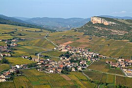 A general view of Vergisson | |
show Location of Vergisson | |
 Vergisson | |
| Coordinates: 46°18′32″N 4°42′55″E / 46.3088°N 4.71520°ECoordinates: 46°18′32″N 4°42′55″E / 46.3088°N 4.71520°E | |
| Country | France |
| Region | Bourgogne-Franche-Comté |
| Department | Saône-et-Loire |
| Arrondissement | Mâcon |
| Canton | La Chapelle-de-Guinchay |
| Area 1 | 5.77 km2 (2.23 sq mi) |
| Population (Jan. 2018)[1] | 256 |
| • Density | 44/km2 (110/sq mi) |
| Time zone | UTC+01:00 (CET) |
| • Summer (DST) | UTC+02:00 (CEST) |
| INSEE/Postal code | 71567 /71960 |
| Elevation | 255–575 m (837–1,886 ft) (avg. 320 m or 1,050 ft) |
| 1 French Land Register data, which excludes lakes, ponds, glaciers > 1 km2 (0.386 sq mi or 247 acres) and river estuaries. | |


Vergisson is a commune in the Saône-et-Loire department in the region of Bourgogne-Franche-Comté in eastern France.
Wine[]
The vineyards of Vergisson form part of the appellation d'origine contrôlée Pouilly-Fuissé.
Gallery[]

View from Rock of Solutré.

View from Rock of Vergisson.

View from Menhir de Chancerons.

Menhir de Chancerons.

Église Saint-Martin.

Église Saint-Martin (view N).

Wayside cross (1855).


See also[]
References[]
- ^ "Populations légales 2018". INSEE. 28 December 2020.
| Wikimedia Commons has media related to Vergisson. |
This Saône-et-Loire geographical article is a stub. You can help Wikipedia by . |
Categories:
- Communes of Saône-et-Loire
- Saône-et-Loire geography stubs