Étainhus
Étainhus | |
|---|---|
 The church in Étainhus | |
 Coat of arms | |
show Location of Étainhus | |
 Étainhus | |
| Coordinates: 49°34′05″N 0°18′49″E / 49.5681°N 0.3136°ECoordinates: 49°34′05″N 0°18′49″E / 49.5681°N 0.3136°E | |
| Country | France |
| Region | Normandy |
| Department | Seine-Maritime |
| Arrondissement | Le Havre |
| Canton | Saint-Romain-de-Colbosc |
| Intercommunality | Le Havre Seine Métropole |
| Government | |
| • Mayor (2020–2026) | Rémi Malo |
| Area 1 | 8.22 km2 (3.17 sq mi) |
| Population (Jan. 2018)[1] | 1,197 |
| • Density | 150/km2 (380/sq mi) |
| Time zone | UTC+01:00 (CET) |
| • Summer (DST) | UTC+02:00 (CEST) |
| INSEE/Postal code | 76250 /76430 |
| Elevation | 87–126 m (285–413 ft) (avg. 106 m or 348 ft) |
| 1 French Land Register data, which excludes lakes, ponds, glaciers > 1 km2 (0.386 sq mi or 247 acres) and river estuaries. | |


Étainhus (French pronunciation: [etɛ̃.y]) is a commune in the Seine-Maritime department in the Normandy region in northern France.
Heraldry[]
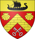 |
The arms of Étainhus are blazoned : Gules, a chevron Or masoned sable between 2 escallops Or and 2 keys in saltire argent, and on a chief Or a drakkar sable.
|
Geography[]
Étainhus is a farming village in the Pays de Caux, situated some 10 miles (16 km) northeast of Le Havre, at the junction of the D234 and D39 roads.
Population[]
| Year | 1962 | 1968 | 1975 | 1982 | 1990 | 1999 | 2006 |
|---|---|---|---|---|---|---|---|
| Population | 529 | 531 | 542 | 609 | 926 | 1007 | 1057 |
| From the year 1962 on: No double counting—residents of multiple communes (e.g. students and military personnel) are counted only once. | |||||||
Places of interest[]
- The church of St. Jacques, dating from the eleventh century.
See also[]
- Tramway de Saint-Romain-de-Colbosc
- Communes of the Seine-Maritime department
References[]
- ^ "Populations légales 2018". INSEE. 28 December 2020.
| Wikimedia Commons has media related to Étainhus. |
| show Communes of the Seine-Maritime department |
|---|
Categories:
- Communes of Seine-Maritime
- Le Havre geography stubs