Grèges
Grèges | |
|---|---|
 The town hall in Grèges | |
 Coat of arms | |
show Location of Grèges | |
 Grèges | |
| Coordinates: 49°55′25″N 1°08′45″E / 49.9236°N 1.1458°ECoordinates: 49°55′25″N 1°08′45″E / 49.9236°N 1.1458°E | |
| Country | France |
| Region | Normandy |
| Department | Seine-Maritime |
| Arrondissement | Dieppe |
| Canton | Dieppe-2 |
| Intercommunality | CA Région Dieppoise |
| Government | |
| • Mayor (2020–2026) | Daniel Lefèvre |
| Area 1 | 3.13 km2 (1.21 sq mi) |
| Population (Jan. 2018)[1] | 843 |
| • Density | 270/km2 (700/sq mi) |
| Time zone | UTC+01:00 (CET) |
| • Summer (DST) | UTC+02:00 (CEST) |
| INSEE/Postal code | 76324 /76370 |
| Elevation | 74–101 m (243–331 ft) (avg. 95 m or 312 ft) |
| 1 French Land Register data, which excludes lakes, ponds, glaciers > 1 km2 (0.386 sq mi or 247 acres) and river estuaries. | |


Grèges is a commune in the Seine-Maritime department in the Normandy region in northern France.
Geography[]
A farming and suburban village situated in the Pays de Caux, some 2 miles (3.2 km) east of Dieppe at the junction of the D920 and the D100 roads.
Heraldry[]
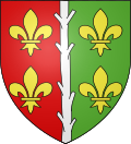 |
The arms of Grèges are blazoned : Per pale gules and vert, a pallet ?raguly? argent between 4 fleurs-de-lys Or. (the centre charge might also be blasoned 'a lopped branch palewise', as it is not what English would describe as 'raguly'.
|
Population[]
| Year | 1962 | 1968 | 1975 | 1982 | 1990 | 1999 | 2006 |
|---|---|---|---|---|---|---|---|
| Population | 323 | 333 | 383 | 594 | 761 | 742 | 796 |
| From the year 1962 on: No double counting—residents of multiple communes (e.g. students and military personnel) are counted only once. | |||||||
Places of interest[]
- The church of St.Madeleine, dating from the sixteenth century.
- The ruins of a 15th-century presbytery.
See also[]
- Communes of the Seine-Maritime department
References[]
- ^ "Populations légales 2018". INSEE. 28 December 2020.
| Wikimedia Commons has media related to Grèges. |
| show Communes of the Seine-Maritime department |
|---|
| Authority control |
|
|---|
Categories:
- Communes of Seine-Maritime
- Dieppe geography stubs