Bertrimont
From Wikipedia, the free encyclopedia
Commune in Normandy, France
Bertrimont | |
|---|---|
 Coat of arms | |
 Bertrimont  Bertrimont | |
Coordinates:  49°40′04″N 1°00′06″E / 49.6678°N 1.0017°E / 49.6678; 1.0017Coordinates: 49°40′04″N 1°00′06″E / 49.6678°N 1.0017°E / 49.6678; 1.0017 49°40′04″N 1°00′06″E / 49.6678°N 1.0017°E / 49.6678; 1.0017Coordinates: 49°40′04″N 1°00′06″E / 49.6678°N 1.0017°E / 49.6678; 1.0017 | |
| Country | France |
| Region | Normandy |
| Department | Seine-Maritime |
| Arrondissement | Dieppe |
| Canton | Luneray |
| Intercommunality | CC Terroir de Caux |
| Area 1 | 4.74 km2 (1.83 sq mi) |
| Population (Jan. 2018)[1] | 216 |
| • Density | 46/km2 (120/sq mi) |
| Time zone | UTC+01:00 (CET) |
| • Summer (DST) | UTC+02:00 (CEST) |
| INSEE/Postal code | 76086 /76890 |
| Elevation | 114–162 m (374–531 ft) (avg. 147 m or 482 ft) |
| 1 French Land Register data, which excludes lakes, ponds, glaciers > 1 km2 (0.386 sq mi or 247 acres) and river estuaries. | |

Bertrimont is a commune in the Seine-Maritime department in the Normandy region in northern France.
Geography[]
A small farming village in the Pays de Caux, situated some 20 miles (32 km) south of Dieppe, near the junction of the N29 and the D2 roads.
Heraldry[]
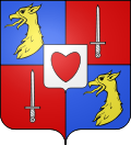 |
The arms of Bertrimont are blazoned : Quarterly 1&4: Azure, a griffon's head Or; 2&3: Gules, a sword argent; overall an inescutcheon Argent, a heart gules.
|
Population[]
| Year | 1962 | 1968 | 1975 | 1982 | 1990 | 1999 | 2006 |
|---|---|---|---|---|---|---|---|
| Population | 95 | 125 | 117 | 115 | 124 | 195 | 245 |
| From the year 1962 on: No double counting—residents of multiple communes (e.g. students and military personnel) are counted only once. | |||||||
Places of interest[]
- The church of St.Pierre, dating from the sixteenth century.
- The feudal motte.
See also[]
- Communes of the Seine-Maritime department
References[]
- ^ "Populations légales 2018". INSEE. 28 December 2020.
| Wikimedia Commons has media related to Bertrimont. |
show
Communes of the Seine-Maritime department | |
|---|---|
|
This Dieppe geographical article is a stub. You can help Wikipedia by . |
- v
- t
Retrieved from ""
Categories:
- Communes of Seine-Maritime
- Dieppe geography stubs
Hidden categories:
- Articles with short description
- Short description is different from Wikidata
- Infobox mapframe without OSM relation ID on Wikidata
- Coordinates on Wikidata
- Pages using infobox settlement with image map1 but not image map
- Commons category link is on Wikidata
- Articles with BNF identifiers
- All stub articles
- Pages using the Kartographer extension