Anquetierville
Anquetierville | |
|---|---|
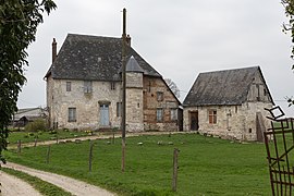 15th-century manor in Anquetierville | |
show Location of Anquetierville | |
 Anquetierville | |
| Coordinates: 49°31′57″N 0°38′08″E / 49.5325°N 0.6356°ECoordinates: 49°31′57″N 0°38′08″E / 49.5325°N 0.6356°E | |
| Country | France |
| Region | Normandy |
| Department | Seine-Maritime |
| Arrondissement | Rouen |
| Canton | Port-Jérôme-sur-Seine |
| Intercommunality | Caux Seine Agglo |
| Government | |
| • Mayor (2020–2026) | Didier Feron[1] |
| Area 1 | 4.08 km2 (1.58 sq mi) |
| Population (Jan. 2018)[2] | 336 |
| • Density | 82/km2 (210/sq mi) |
| Time zone | UTC+01:00 (CET) |
| • Summer (DST) | UTC+02:00 (CEST) |
| INSEE/Postal code | 76022 /76490 |
| Elevation | 98–153 m (322–502 ft) (avg. 135 m or 443 ft) |
| 1 French Land Register data, which excludes lakes, ponds, glaciers > 1 km2 (0.386 sq mi or 247 acres) and river estuaries. | |


Anquetierville is a commune in the Seine-Maritime department in the Normandy region in northern France.
Geography[]
A farming village situated in the Pays de Caux, some 24 miles (39 km) northwest of Rouen at the junction of the D440, D982 and the D28 roads.
Population[]
| Year | 1962 | 1968 | 1975 | 1982 | 1990 | 1999 | 2006 | 2012 |
|---|---|---|---|---|---|---|---|---|
| Population | 195 | 212 | 215 | 258 | 361 | 337 | 366 | 355 |
| From the year 1962 on: No double counting—residents of multiple communes (e.g. students and military personnel) are counted only once. | ||||||||
Places of interest[]
- The church of Saint-Amand, dating from the thirteenth century.
See also[]
- Communes of the Seine-Maritime department
References[]
- ^ "Répertoire national des élus: les maires". data.gouv.fr, Plateforme ouverte des données publiques françaises (in French). 2 December 2020.
- ^ "Populations légales 2018". INSEE. 28 December 2020.
| Wikimedia Commons has media related to Anquetierville. |
| show Communes of the Seine-Maritime department |
|---|
Categories:
- Communes of Seine-Maritime
- Rouen geography stubs