Saint-Martin-l'Hortier
From Wikipedia, the free encyclopedia
Commune in Normandy, France
Saint-Martin-l’Hortier | |
|---|---|
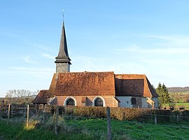 The church in Saint-Martin-l'Hortier | |
 Saint-Martin-l’Hortier  Saint-Martin-l’Hortier | |
Coordinates:  49°44′38″N 1°24′30″E / 49.7439°N 1.4083°E / 49.7439; 1.4083Coordinates: 49°44′38″N 1°24′30″E / 49.7439°N 1.4083°E / 49.7439; 1.4083 49°44′38″N 1°24′30″E / 49.7439°N 1.4083°E / 49.7439; 1.4083Coordinates: 49°44′38″N 1°24′30″E / 49.7439°N 1.4083°E / 49.7439; 1.4083 | |
| Country | France |
| Region | Normandy |
| Department | Seine-Maritime |
| Arrondissement | Dieppe |
| Canton | Neufchâtel-en-Bray |
| Intercommunality | CC Bray-Eawy |
| Government | |
| • Mayor (2020–2026) | Manuel Beauval[1] |
| Area 1 | 5.79 km2 (2.24 sq mi) |
| Population (Jan. 2018)[2] | 274 |
| • Density | 47/km2 (120/sq mi) |
| Time zone | UTC+01:00 (CET) |
| • Summer (DST) | UTC+02:00 (CEST) |
| INSEE/Postal code | 76620 /76270 |
| Elevation | 64–221 m (210–725 ft) (avg. 71 m or 233 ft) |
| 1 French Land Register data, which excludes lakes, ponds, glaciers > 1 km2 (0.386 sq mi or 247 acres) and river estuaries. | |

Saint-Martin-l’Hortier is a commune in the Seine-Maritime department in the Normandy region in northern France.
Geography[]
A small farming village situated by the banks of the Béthune River in the Pays de Bray, at the junction of the roads, some 18 miles (29 km) southeast of Dieppe.
Population[]
| Year | Pop. | ±% p.a. |
|---|---|---|
| 1968 | 160 | — |
| 1975 | 175 | +1.29% |
| 1982 | 202 | +2.07% |
| 1990 | 197 | −0.31% |
| 1999 | 198 | +0.06% |
| 2007 | 239 | +2.38% |
| 2012 | 263 | +1.93% |
| 2017 | 278 | +1.12% |
| Source: INSEE[3] | ||
Places of interest[]
- The church of St. Martin, dating from the seventeenth century.
See also[]
- Communes of the Seine-Maritime department
References[]
- ^ Liste des maires du département de la Seine-Maritime, 10 August 2020
- ^ "Populations légales 2018". INSEE. 28 December 2020.
- ^ Population en historique depuis 1968, INSEE
| Wikimedia Commons has media related to Saint-Martin-l'Hortier. |
show
Communes of the Seine-Maritime department | |
|---|---|
|
This Dieppe geographical article is a stub. You can help Wikipedia by . |
- v
- t
Retrieved from ""
Categories:
- Communes of Seine-Maritime
- Dieppe geography stubs
Hidden categories:
- Articles with short description
- Short description is different from Wikidata
- Infobox mapframe without OSM relation ID on Wikidata
- Coordinates on Wikidata
- Pages using infobox settlement with image map1 but not image map
- Commons category link from Wikidata
- Articles with BNF identifiers
- All stub articles
- Pages using the Kartographer extension