Doudeauville, Seine-Maritime
Doudeauville | |
|---|---|
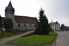 The church and town hall in Doudeauville | |
show Location of Doudeauville | |
 Doudeauville | |
| Coordinates: 49°34′23″N 1°42′20″E / 49.5731°N 1.7056°ECoordinates: 49°34′23″N 1°42′20″E / 49.5731°N 1.7056°E | |
| Country | France |
| Region | Normandy |
| Department | Seine-Maritime |
| Arrondissement | Dieppe |
| Canton | Gournay-en-Bray |
| Intercommunality | CC 4 rivières |
| Government | |
| • Mayor (2020–2026) | Mickaël Beuvin |
| Area 1 | 3.94 km2 (1.52 sq mi) |
| Population (Jan. 2018)[1] | 93 |
| • Density | 24/km2 (61/sq mi) |
| Time zone | UTC+01:00 (CET) |
| • Summer (DST) | UTC+02:00 (CEST) |
| INSEE/Postal code | 76218 /76220 |
| Elevation | 108–206 m (354–676 ft) (avg. 185 m or 607 ft) |
| 1 French Land Register data, which excludes lakes, ponds, glaciers > 1 km2 (0.386 sq mi or 247 acres) and river estuaries. | |


Doudeauville (French pronunciation: [dudovil]) is a commune in the Seine-Maritime department in the Normandy region in northern France.
Geography[]
A very small farming village situated in the Pays de Caux, some 40 miles (64 km) southeast of Dieppe, on the D8 road and in the Epte river valley.
Population[]
| Year | 1962 | 1968 | 1975 | 1982 | 1990 | 1999 | 2006 |
|---|---|---|---|---|---|---|---|
| Population | 88 | 108 | 102 | 72 | 68 | 81 | 99 |
| From the year 1962 on: No double counting—residents of multiple communes (e.g. students and military personnel) are counted only once. | |||||||
Places of interest[]
- The church of St. Aubin, dating from the sixteenth century.
- The chapel of St.Clothilde, dating from the nineteenth century.
See also[]
- Communes of the Seine-Maritime department
References[]
- ^ "Populations légales 2018". INSEE. 28 December 2020.
| Wikimedia Commons has media related to Doudeauville (Seine-Maritime). |
| show Communes of the Seine-Maritime department |
|---|
Categories:
- Communes of Seine-Maritime
- Dieppe geography stubs