Clais
From Wikipedia, the free encyclopedia
Commune in Normandy, France
Clais | |
|---|---|
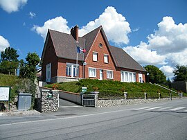 The town hall and school in Clais | |
 Clais  Clais | |
Coordinates:  49°48′31″N 1°27′01″E / 49.8086°N 1.4503°E / 49.8086; 1.4503Coordinates: 49°48′31″N 1°27′01″E / 49.8086°N 1.4503°E / 49.8086; 1.4503 49°48′31″N 1°27′01″E / 49.8086°N 1.4503°E / 49.8086; 1.4503Coordinates: 49°48′31″N 1°27′01″E / 49.8086°N 1.4503°E / 49.8086; 1.4503 | |
| Country | France |
| Region | Normandy |
| Department | Seine-Maritime |
| Arrondissement | Dieppe |
| Canton | Neufchâtel-en-Bray |
| Intercommunality | CC Londinières |
| Government | |
| • Mayor (2020–2026) | Vincent Leborgne |
| Area 1 | 12.45 km2 (4.81 sq mi) |
| Population (Jan. 2018)[1] | 259 |
| • Density | 21/km2 (54/sq mi) |
| Time zone | UTC+01:00 (CET) |
| • Summer (DST) | UTC+02:00 (CEST) |
| INSEE/Postal code | 76175 /76660 |
| Elevation | 86–224 m (282–735 ft) (avg. 98 m or 322 ft) |
| 1 French Land Register data, which excludes lakes, ponds, glaciers > 1 km2 (0.386 sq mi or 247 acres) and river estuaries. | |

Clais is a commune in the Seine-Maritime department in the Normandy region in northern France.
Geography[]
A farming village situated by the banks of the river Eaulne in the Pays de Bray, some 24 miles (39 km) southeast of Dieppe, at the junction of the D1314 and the D14 roads.
Population[]
| Year | 1962 | 1968 | 1975 | 1982 | 1990 | 1999 | 2006 |
|---|---|---|---|---|---|---|---|
| Population | 274 | 289 | 259 | 244 | 209 | 202 | 206 |
| From the year 1962 on: No double counting—residents of multiple communes (e.g. students and military personnel) are counted only once. | |||||||
Places of interest[]
- The church of St.Martin, dating from the eleventh century.
See also[]
- Communes of the Seine-Maritime department
References[]
- ^ "Populations légales 2018". INSEE. 28 December 2020.
External links[]
| Wikimedia Commons has media related to Clais. |
- Clais on the Quid website (in French)
show
Communes of the Seine-Maritime department | |
|---|---|
|
This Dieppe geographical article is a stub. You can help Wikipedia by . |
- v
- t
Retrieved from ""
Categories:
- Communes of Seine-Maritime
- Dieppe geography stubs
Hidden categories:
- Articles with short description
- Short description is different from Wikidata
- Infobox mapframe without OSM relation ID on Wikidata
- Coordinates on Wikidata
- Pages using infobox settlement with image map1 but not image map
- Commons category link from Wikidata
- Articles with French-language sources (fr)
- Articles with BNF identifiers
- All stub articles
- Pages using the Kartographer extension