Fresne-le-Plan
From Wikipedia, the free encyclopedia
Commune in Normandy, France
Fresne-le-Plan | |
|---|---|
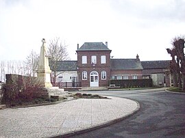 The town hall in Fresne-le-Plan | |
 Fresne-le-Plan  Fresne-le-Plan | |
Coordinates:  49°24′48″N 1°17′45″E / 49.4133°N 1.2958°E / 49.4133; 1.2958Coordinates: 49°24′48″N 1°17′45″E / 49.4133°N 1.2958°E / 49.4133; 1.2958 49°24′48″N 1°17′45″E / 49.4133°N 1.2958°E / 49.4133; 1.2958Coordinates: 49°24′48″N 1°17′45″E / 49.4133°N 1.2958°E / 49.4133; 1.2958 | |
| Country | France |
| Region | Normandy |
| Department | Seine-Maritime |
| Arrondissement | Rouen |
| Canton | Le Mesnil-Esnard |
| Government | |
| • Mayor (2014-2020) | Antoine Maillard |
| Area 1 | 6.88 km2 (2.66 sq mi) |
| Population (Jan. 2018)[1] | 592 |
| • Density | 86/km2 (220/sq mi) |
| Time zone | UTC+01:00 (CET) |
| • Summer (DST) | UTC+02:00 (CEST) |
| INSEE/Postal code | 76285 /76520 |
| Elevation | 125–161 m (410–528 ft) (avg. 155 m or 509 ft) |
| 1 French Land Register data, which excludes lakes, ponds, glaciers > 1 km2 (0.386 sq mi or 247 acres) and river estuaries. | |

Fresne-le-Plan is a commune in the Seine-Maritime department in the Normandy region in north-western France.
Geography[]
A farming village situated on the border with the department of Eure, some 11 miles (18 km) east of Rouen, at the junction of the D 13 and the D 42 roads.
Population[]
| Year | 1962 | 1968 | 1975 | 1982 | 1990 | 1999 | 2004 | 2006 | 2009 | 2011 |
|---|---|---|---|---|---|---|---|---|---|---|
| Population | 219 | 232 | 320 | 369 | 379 | 456 | 506 | 531 | 595 | 631 |
| From the year 1962 on: No double counting—residents of multiple communes (e.g. students and military personnel) are counted only once. | ||||||||||
Places of interest[]
- The church of Sts.Pierre & Paul, dating from the thirteenth century.
- The dovecote of Mesnil Grain.
See also[]
- Communes of the Seine-Maritime department
References[]
- ^ "Populations légales 2018". INSEE. 28 December 2020.
| Wikimedia Commons has media related to Fresne-le-Plan. |
show
Communes of the Seine-Maritime department | |
|---|---|
|
This Rouen geographical article is a stub. You can help Wikipedia by . |
- v
- t
Retrieved from ""
Categories:
- Communes of Seine-Maritime
- Rouen geography stubs
Hidden categories:
- Articles with short description
- Short description is different from Wikidata
- Infobox mapframe without OSM relation ID on Wikidata
- Coordinates on Wikidata
- Pages using infobox settlement with image map1 but not image map
- Commons category link from Wikidata
- Articles with BNF identifiers
- All stub articles
- Pages using the Kartographer extension