Şırnak
Şırnak | |
|---|---|
 | |
 Şırnak | |
| Coordinates: 37°30′59″N 42°27′40″E / 37.51639°N 42.46111°ECoordinates: 37°30′59″N 42°27′40″E / 37.51639°N 42.46111°E | |
| Country | Turkey |
| Province | Şırnak |
| Government | |
| • Mayor | Mehmet Yarka (AKP) |
| • Governor | Mehmet Aktaş |
| Area | |
| • District | 1,863.61 km2 (719.54 sq mi) |
| Elevation | 1,650 m (5,410 ft) |
| Population (2012)[2] | |
| • Urban | 63,298 |
| • District | 87,719 |
| • District density | 47/km2 (120/sq mi) |
| Website | www.sirnak.bel.tr www.sirnak.gov.tr |


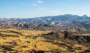
Şırnak (Kurdish: Şirnex)[3][4] is a town in southeastern Turkey. It is the capital of Şırnak Province, a new province that split from the Mardin and Siirt provinces. The Habur border gate with Iraq which is one of Turkey's main links to Arab countries is also on Şırnak.
Names[]
The settlement was originally called Şehr-i Nuh (City of Noah) since it was near Cudi Mountain where Noah's Ark finally believed to have landed after the Flood.
History[]
During the Guti Empire's reign in the region, a special inscription style called "civi zend" was invented. Mount Cudi, surrounded by other mountains to the east and northeast and plains to the west and southwest has a unique place in history. It is the mountain on which Noah's Ark is believed to have landed. One of its peaks, at over 2000 meters, is "Noah's Visit" (some Islamic scholars argue that Noah landed on Cudi mountain).
Other historical assets of Şırnak include a rock carving from the Assyrians describing a figure on horseback (in Meseici village near Kasrik Pass); other rock carvings dating back to the Neolithic Age which corresponds to 7000 BC (in Beytüşşebap); fortresses of Kale, Meme Kale and Kaletivuru; bridges of the Kasrik Pass which reflect the art stone working in the time of Seljuks; and Virgin Mary Church in Cizre (not to be confused with the one in Ephesus).
1992 Turkish military operation[]
On 18 August 1992, fighting broke out between Turkish security forces and Kurdish separatists of the PKK. 20,000 out of 25,000 residents fled the city during the three days of fighting.
While the town was under bombardment, there was no way to get an account of what was happening in the region as journalists were prevented from entering the city centre which was completely burned down by the security forces. Şırnak was under fire for three days and tanks and cannons were used to hit buildings occupied by civilians.[5]
On 26 August 1992, Amnesty International sent requests to then Prime Minister, Süleyman Demirel, Interior Minister Ismet Sezgin, Emergency Legislation Governor Ünal Erkan and Şırnak province governor Mustafa Mala, to immediately initiate an independent and impartial inquiry into the events, to ensure no-one was mistreated in police custody and to make their findings public.
2016 Turkish military operation[]
On 13 March 2016 military operations by Turkish security forces began against PKK. The military curfew imposed on the Kurdish city was lifted after 246 days. Neighbourhoods like Gazipasha, Yeshilyurt, Ismetpasha, Dicle, Cumhuriyet and Bahçelievler were completely destroyed in the war.[6]
Demographics and Geography[]
The population of Şırnak province is 430,424 (2009 census) living in an area extending over 7,172 square kilometers. Beytüşşebap, Cizre, Guclukonak, Idil, Silopi and Uludere are the administrative districts of Şırnak. The population of the Şırnak city is 63,664. The total fertility rate is one of the highest in Turkey at 3.21 children per woman.
Climate[]
Şırnak has a hot-summer Mediterranean climate (Köppen: Csa, Trewartha: Cs) with chilly, snowy winters and very hot, dry summers. Humidity is always low throughout the year due to its inland location. February and March are the wettest months, July and August are the driest, with virtually no precipitation at all.
| hideClimate data for Şırnak (1991–2020, extremes 1970–2020) | |||||||||||||
|---|---|---|---|---|---|---|---|---|---|---|---|---|---|
| Month | Jan | Feb | Mar | Apr | May | Jun | Jul | Aug | Sep | Oct | Nov | Dec | Year |
| Record high °C (°F) | 18.1 (64.6) |
17.3 (63.1) |
24.8 (76.6) |
29.0 (84.2) |
31.8 (89.2) |
37.5 (99.5) |
40.4 (104.7) |
40.3 (104.5) |
37.1 (98.8) |
31.3 (88.3) |
22.6 (72.7) |
22.5 (72.5) |
40.4 (104.7) |
| Average high °C (°F) | 5.9 (42.6) |
7.4 (45.3) |
12.0 (53.6) |
16.7 (62.1) |
23.0 (73.4) |
30.1 (86.2) |
34.2 (93.6) |
34.0 (93.2) |
29.4 (84.9) |
22.0 (71.6) |
13.5 (56.3) |
8.4 (47.1) |
19.7 (67.5) |
| Daily mean °C (°F) | 2.6 (36.7) |
3.8 (38.8) |
8.1 (46.6) |
12.5 (54.5) |
18.7 (65.7) |
25.3 (77.5) |
29.5 (85.1) |
29.3 (84.7) |
24.7 (76.5) |
17.8 (64.0) |
9.9 (49.8) |
5.1 (41.2) |
15.6 (60.1) |
| Average low °C (°F) | −0.4 (31.3) |
0.5 (32.9) |
4.2 (39.6) |
8.2 (46.8) |
13.9 (57.0) |
20.1 (68.2) |
24.3 (75.7) |
24.1 (75.4) |
19.7 (67.5) |
13.3 (55.9) |
6.0 (42.8) |
1.7 (35.1) |
11.3 (52.3) |
| Record low °C (°F) | −14.5 (5.9) |
−13.2 (8.2) |
−11.2 (11.8) |
−4.7 (23.5) |
0.8 (33.4) |
9.2 (48.6) |
13.1 (55.6) |
15.0 (59.0) |
3.2 (37.8) |
−0.5 (31.1) |
−5.0 (23.0) |
−10.8 (12.6) |
−14.5 (5.9) |
| Average precipitation mm (inches) | 107.3 (4.22) |
103.8 (4.09) |
125.8 (4.95) |
115.1 (4.53) |
52.6 (2.07) |
5.3 (0.21) |
6.1 (0.24) |
0.7 (0.03) |
13.2 (0.52) |
54.6 (2.15) |
82.5 (3.25) |
101.2 (3.98) |
768.2 (30.24) |
| Average precipitation days | 9.04 | 9.11 | 10.52 | 10.44 | 6.74 | 1.70 | 0.78 | 0.48 | 1.07 | 5.81 | 7.63 | 10.22 | 73.5 |
| Mean monthly sunshine hours | 96.1 | 121.5 | 170.5 | 219.0 | 263.5 | 318.0 | 347.2 | 350.3 | 306.0 | 223.2 | 153.0 | 99.2 | 2,667.5 |
| Mean daily sunshine hours | 3.1 | 4.3 | 5.5 | 7.3 | 8.5 | 10.6 | 11.2 | 11.3 | 10.2 | 7.2 | 5.1 | 3.2 | 7.3 |
| Source: Turkish State Meteorological Service[7] | |||||||||||||
Politics[]
The mayor of Şırnak, Ramazan Uysal, was arrested in October 2011, as part of the KCK investigation, and, as of 12 October 2011, remains in detention.
On 15 October 2011 it was announced that the Ministry of the Interior had suspended him from his functions. [8]
On March 29, 2019, elections, Sirnak mayoral position has been win by AKP (19.718 or 61,72%) over HDP (11.194 or 35,04%).[9]
Economy[]
In Şırnak, agriculture, animal husbandry and border trade form the backbone of economic life. Wheat, barley and lentil are the main crops. Cotton is grown as an industrial crop. Cizre and Silopi raise high quality pomegranate and grape. Animal husbandry is practiced by nomadic people. They mainly breed sheep and various types of goats (ordinary goat, Angora goat, and brown haired goat specific to the area). Traditional handicrafts consist of carpet, kilim and bag weaving. Şırnak scarves are woven out of sheep and goat wool. Beytüşşebap is well known for its kilims. Nevertheless, Sirnak province is the poorest province of Turkey in terms of per capita income. Its per capita income comes around to around 700 USD, which is similar to that of many sub-Saharan African countries. But in the future, Şırnak has the potential to flourish from meat processing, leather industries and asphalt mining, which has an estimated reserve of 29 million tons.
References[]
- ^ "Area of regions (including lakes), km²". Regional Statistics Database. Turkish Statistical Institute. 2002. Retrieved 2013-03-05.
- ^ "Population of province/district centers and towns/villages by districts - 2012". Address Based Population Registration System (ABPRS) Database. Turkish Statistical Institute. Retrieved 2013-02-27.
- ^ Jwaideh, Wadie (1919-03-19). The Kurdish national movement: its. ISBN 9780815630937. Retrieved 2010-08-22 – via Google Books.
- ^ "Koerdisch kind blind geraakt door Turkse politie". Rudaw.nl. Retrieved 2010-08-22.
- ^ nytimes
- ^ http://kurdishquestion.com/article/3612-246-days-after-curfew-and-siege-sirnak-in-photos
- ^ "Resmi İstatistikler: İllerimize Ait Mevism Normalleri (1991–2020)" (in Turkish). Turkish State Meteorological Service. Retrieved 3 May 2021.
- ^ "31 elected Kurdish politicians dismissed without waiting trials' results". Dicle News Agency. 2011-10-15. Retrieved 2011-10-16.
- ^ http://www.hurriyetdailynews.com/secim/31-mart-2019-yerel-secimleri/sirnak-belediye-baskani-adaylari
External links[]
| show Şırnak in Şırnak Province of Turkey |
|---|
| show Authority control |
|---|
- Şırnak
- Districts of Şırnak Province
- Populated places in Şırnak Province
- Kurdish settlements in Turkey