Calmont, Aveyron
show This article may be expanded with text translated from the corresponding article in French. (December 2008) Click [show] for important translation instructions. |
Calmont | |
|---|---|
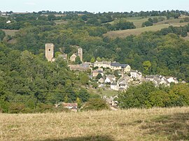 A general view of Calmont | |
 Coat of arms | |
show Location of Calmont | |
 Calmont | |
| Coordinates: 44°14′59″N 2°30′48″E / 44.2497°N 2.5133°ECoordinates: 44°14′59″N 2°30′48″E / 44.2497°N 2.5133°E | |
| Country | France |
| Region | Occitanie |
| Department | Aveyron |
| Arrondissement | Villefranche-de-Rouergue |
| Canton | Monts du Réquistanais |
| Government | |
| • Mayor (2020–2026) | David Mazars |
| Area 1 | 30.89 km2 (11.93 sq mi) |
| Population (Jan. 2018)[1] | 2,109 |
| • Density | 68/km2 (180/sq mi) |
| Time zone | UTC+01:00 (CET) |
| • Summer (DST) | UTC+02:00 (CEST) |
| INSEE/Postal code | 12043 /12450 |
| Elevation | 473–755 m (1,552–2,477 ft) (avg. 700 m or 2,300 ft) |
| 1 French Land Register data, which excludes lakes, ponds, glaciers > 1 km2 (0.386 sq mi or 247 acres) and river estuaries. | |


Calmont (French pronunciation: [kalmɔ̃]) is a commune in the Aveyron department in southern France.
Population[]
| Year | Pop. | ±% |
|---|---|---|
| 1962 | 1,101 | — |
| 1968 | 1,163 | +5.6% |
| 1975 | 1,116 | −4.0% |
| 1982 | 1,224 | +9.7% |
| 1990 | 1,437 | +17.4% |
| 1999 | 1,582 | +10.1% |
| 2008 | 1,942 | +22.8% |
See also[]
References[]
- ^ "Populations légales 2018". INSEE. 28 December 2020.
| Wikimedia Commons has media related to Calmont (Aveyron). |
This Aveyron geographical article is a stub. You can help Wikipedia by . |
Categories:
- Communes of Aveyron
- Aveyron geography stubs