Saint-Hippolyte, Aveyron
show This article may be expanded with text translated from the corresponding article in French. (December 2008) Click [show] for important translation instructions. |
Saint-Hippolyte | |
|---|---|
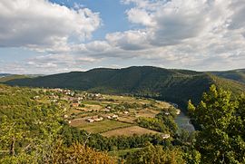 The Tarn Valley at Saint-Hippolyte | |
show Location of Saint-Hippolyte | |
 Saint-Hippolyte | |
| Coordinates: 44°42′43″N 2°35′33″E / 44.7119°N 2.5925°ECoordinates: 44°42′43″N 2°35′33″E / 44.7119°N 2.5925°E | |
| Country | France |
| Region | Occitanie |
| Department | Aveyron |
| Arrondissement | Rodez |
| Canton | Lot et Truyère |
| Government | |
| • Mayor (2008–2014) | Didier Cayla |
| Area 1 | 36.87 km2 (14.24 sq mi) |
| Population (Jan. 2018)[1] | 427 |
| • Density | 12/km2 (30/sq mi) |
| Time zone | UTC+01:00 (CET) |
| • Summer (DST) | UTC+02:00 (CEST) |
| INSEE/Postal code | 12226 /12140 |
| Elevation | 228–785 m (748–2,575 ft) (avg. 675 m or 2,215 ft) |
| 1 French Land Register data, which excludes lakes, ponds, glaciers > 1 km2 (0.386 sq mi or 247 acres) and river estuaries. | |


Saint-Hippolyte (Occitan: Sent Ipòli) is a commune in the Aveyron department in southern France.
Population[]
| Year | Pop. | ±% |
|---|---|---|
| 1962 | 713 | — |
| 1968 | 825 | +15.7% |
| 1975 | 677 | −17.9% |
| 1982 | 685 | +1.2% |
| 1990 | 541 | −21.0% |
| 1999 | 500 | −7.6% |
| 2008 | 453 | −9.4% |
See also[]
References[]
- ^ "Populations légales 2018". INSEE. 28 December 2020.
| Wikimedia Commons has media related to Saint-Hippolyte (Aveyron). |
This Aveyron geographical article is a stub. You can help Wikipedia by . |
Categories:
- Communes of Aveyron
- Aveyron geography stubs