Manhac
show This article may be expanded with text translated from the corresponding article in French. (December 2008) Click [show] for important translation instructions. |
Manhac | |
|---|---|
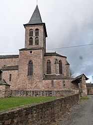 The church in Manhac | |
show Location of Manhac | |
 Manhac | |
| Coordinates: 44°15′20″N 2°28′12″E / 44.2556°N 2.47°ECoordinates: 44°15′20″N 2°28′12″E / 44.2556°N 2.47°E | |
| Country | France |
| Region | Occitanie |
| Department | Aveyron |
| Arrondissement | Villefranche-de-Rouergue |
| Canton | Ceor-Ségala |
| Government | |
| • Mayor (2008–2014) | Christian Rey |
| Area 1 | 1.5 km2 (0.6 sq mi) |
| Population (Jan. 2018)[1] | 828 |
| • Density | 550/km2 (1,400/sq mi) |
| Time zone | UTC+01:00 (CET) |
| • Summer (DST) | UTC+02:00 (CEST) |
| INSEE/Postal code | 12137 /12160 |
| Elevation | 459–793 m (1,506–2,602 ft) (avg. 630 m or 2,070 ft) |
| 1 French Land Register data, which excludes lakes, ponds, glaciers > 1 km2 (0.386 sq mi or 247 acres) and river estuaries. | |


Manhac is a commune in the Aveyron department in southern France.
Population[]
| Year | Pop. | ±% |
|---|---|---|
| 1962 | 481 | — |
| 1968 | 544 | +13.1% |
| 1975 | 505 | −7.2% |
| 1982 | 442 | −12.5% |
| 1990 | 375 | −15.2% |
| 1999 | 504 | +34.4% |
| 2008 | 663 | +31.5% |
See also[]
References[]
- ^ "Populations légales 2018". INSEE. 28 December 2020.
| Wikimedia Commons has media related to Manhac. |
This Aveyron geographical article is a stub. You can help Wikipedia by . |
Categories:
- Communes of Aveyron
- Aveyron geography stubs