Sénergues
show This article may be expanded with text translated from the corresponding article in French. (December 2008) Click [show] for important translation instructions. |
Sénergues | |
|---|---|
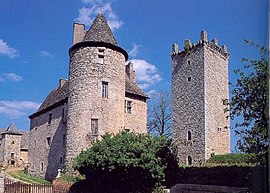 The chateau in Sénergues | |
show Location of Sénergues | |
 Sénergues | |
| Coordinates: 44°36′24″N 2°29′08″E / 44.6067°N 2.4856°ECoordinates: 44°36′24″N 2°29′08″E / 44.6067°N 2.4856°E | |
| Country | France |
| Region | Occitanie |
| Department | Aveyron |
| Arrondissement | Rodez |
| Canton | Lot et Dourdou |
| Government | |
| • Mayor (2020–2026) | Daniel Joulia |
| Area 1 | 44.9 km2 (17.3 sq mi) |
| Population (Jan. 2018)[1] | 421 |
| • Density | 9.4/km2 (24/sq mi) |
| Time zone | UTC+01:00 (CET) |
| • Summer (DST) | UTC+02:00 (CEST) |
| INSEE/Postal code | 12268 /12320 |
| Elevation | 188–664 m (617–2,178 ft) (avg. 550 m or 1,800 ft) |
| 1 French Land Register data, which excludes lakes, ponds, glaciers > 1 km2 (0.386 sq mi or 247 acres) and river estuaries. | |


Sénergues (French pronunciation: [senɛʁg]; Languedocien: Senèrgas) is a commune in the Aveyron department in southern France.
Population[]
| Year | Pop. | ±% |
|---|---|---|
| 1962 | 886 | — |
| 1968 | 898 | +1.4% |
| 1975 | 815 | −9.2% |
| 1982 | 732 | −10.2% |
| 1990 | 608 | −16.9% |
| 1999 | 545 | −10.4% |
| 2008 | 487 | −10.6% |
See also[]
References[]
- ^ "Populations légales 2018". INSEE. 28 December 2020.
| Wikimedia Commons has media related to Sénergues. |
| show Authority control |
|---|
This Aveyron geographical article is a stub. You can help Wikipedia by . |
Categories:
- Communes of Aveyron
- Aveyron geography stubs