Quins, Aveyron
show This article may be expanded with text translated from the corresponding article in French. (December 2008) Click [show] for important translation instructions. |
Quins | |
|---|---|
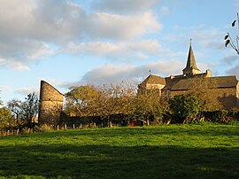 A general view of Quins | |
show Location of Quins | |
 Quins | |
| Coordinates: 44°14′00″N 2°22′25″E / 44.2333°N 2.3736°ECoordinates: 44°14′00″N 2°22′25″E / 44.2333°N 2.3736°E | |
| Country | France |
| Region | Occitanie |
| Department | Aveyron |
| Arrondissement | Villefranche-de-Rouergue |
| Canton | Ceor-Ségala |
| Government | |
| • Mayor (2020–2026) | Jean-Pierre Mazars[1] |
| Area 1 | 38.46 km2 (14.85 sq mi) |
| Population (Jan. 2018)[2] | 849 |
| • Density | 22/km2 (57/sq mi) |
| Time zone | UTC+01:00 (CET) |
| • Summer (DST) | UTC+02:00 (CEST) |
| INSEE/Postal code | 12194 /12800 |
| Elevation | 343–724 m (1,125–2,375 ft) (avg. 608 m or 1,995 ft) |
| 1 French Land Register data, which excludes lakes, ponds, glaciers > 1 km2 (0.386 sq mi or 247 acres) and river estuaries. | |


Quins is a commune in the Aveyron department in southern France.
Population[]
| Year | Pop. | ±% |
|---|---|---|
| 1962 | 942 | — |
| 1968 | 1,053 | +11.8% |
| 1975 | 886 | −15.9% |
| 1982 | 715 | −19.3% |
| 1990 | 717 | +0.3% |
| 1999 | 648 | −9.6% |
| 2008 | 798 | +23.1% |
See also[]
References[]
- ^ "Répertoire national des élus: les maires". data.gouv.fr, Plateforme ouverte des données publiques françaises (in French). 2 December 2020.
- ^ "Populations légales 2018". INSEE. 28 December 2020.
| Wikimedia Commons has media related to Quins. |
This Aveyron geographical article is a stub. You can help Wikipedia by . |
Categories:
- Communes of Aveyron
- Aveyron geography stubs