Saint-Georges-de-Luzençon
show This article may be expanded with text translated from the corresponding article in French. (December 2008) Click [show] for important translation instructions. |
Saint-Georges-de-Luzençon | |
|---|---|
 Les Brouzes | |
 Coat of arms | |
show Location of Saint-Georges-de-Luzençon | |
 Saint-Georges-de-Luzençon | |
| Coordinates: 44°03′55″N 2°59′11″E / 44.0653°N 2.9864°ECoordinates: 44°03′55″N 2°59′11″E / 44.0653°N 2.9864°E | |
| Country | France |
| Region | Occitanie |
| Department | Aveyron |
| Arrondissement | Millau |
| Canton | Millau-1 |
| Intercommunality | Millau Grands Causses |
| Government | |
| • Mayor (2008–2014) | Gérard Prêtre |
| Area 1 | 47.73 km2 (18.43 sq mi) |
| Population (Jan. 2018)[1] | 1,607 |
| • Density | 34/km2 (87/sq mi) |
| Time zone | UTC+01:00 (CET) |
| • Summer (DST) | UTC+02:00 (CEST) |
| INSEE/Postal code | 12225 /12100 |
| Elevation | 340–782 m (1,115–2,566 ft) (avg. 356 m or 1,168 ft) |
| 1 French Land Register data, which excludes lakes, ponds, glaciers > 1 km2 (0.386 sq mi or 247 acres) and river estuaries. | |


Saint-Georges-de-Luzençon (French pronunciation: [sɛ̃ ʒɔʁʒ də lyzɑ̃sɔ̃]; Occitan: Sent Jòrdi) is a commune in the Aveyron department in southern France. The commune was part of the Rouergue province, where people communicated with a variation of the Occitan language, .
Population[]
| Year | Pop. | ±% |
|---|---|---|
| 1962 | 793 | — |
| 1968 | 827 | +4.3% |
| 1975 | 777 | −6.0% |
| 1982 | 1,027 | +32.2% |
| 1990 | 1,144 | +11.4% |
| 1999 | 1,301 | +13.7% |
| 2008 | 1,673 | +28.6% |
Its inhabitants are called Saint-Georgiens.
Geography[]
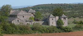
The territory of the commune is a part of the South Massif Central. The village itself is nestled in the valley along the D992 road. The hearth of the village is composed of stonework basements following the forms of the Middle Ages fortress. The main avenue, lately built, welcomes the totality of the commerces. Finally, most of the village surface is occupied by little houses grouped in lots, on a typical contemporary style. In spite of the fact that the village is distant of a dozen kilometers from the nearby city of Millau, it continues to welcome families by reason of its intermediate position with Millau, Saint Affrique and the Roquefort cheese factories in Roquefort-sur-Soulzon.
History[]
Old settlement : Dolmens, fragments of pottery from the 4th century, barbarian cemetery in Briadels. Territory exchanged between the Rodez bishop and the Toulouse count, devastated by the Protestants of Las Ribes in the 16th century, and the ones of the Rohan duke in the 17th.
See also[]
References[]
- ^ "Populations légales 2018". INSEE. 28 December 2020.
| Wikimedia Commons has media related to Saint-Georges-de-Luzençon. |
| show Authority control |
|---|
This Aveyron geographical article is a stub. You can help Wikipedia by . |
- Communes of Aveyron
- Aveyron geography stubs