Viala-du-Pas-de-Jaux
show This article may be expanded with text translated from the corresponding article in French. (December 2008) Click [show] for important translation instructions. |
Viala-du-Pas-de-Jaux | |
|---|---|
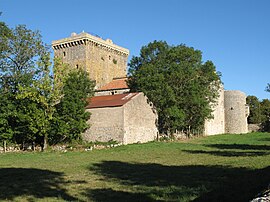 The tower in Viala-du-Pas-de-Jaux | |
show Location of Viala-du-Pas-de-Jaux | |
 Viala-du-Pas-de-Jaux | |
| Coordinates: 43°57′27″N 3°03′23″E / 43.9575°N 3.0564°ECoordinates: 43°57′27″N 3°03′23″E / 43.9575°N 3.0564°E | |
| Country | France |
| Region | Occitanie |
| Department | Aveyron |
| Arrondissement | Millau |
| Canton | Causses-Rougiers |
| Intercommunality | Larzac et Vallées |
| Government | |
| • Mayor (2008–2014) | Nicole Chaudesaygues |
| Area 1 | 18.95 km2 (7.32 sq mi) |
| Population (Jan. 2018)[1] | 98 |
| • Density | 5.2/km2 (13/sq mi) |
| Time zone | UTC+01:00 (CET) |
| • Summer (DST) | UTC+02:00 (CEST) |
| INSEE/Postal code | 12295 /12250 |
| Elevation | 720–879 m (2,362–2,884 ft) (avg. 810 m or 2,660 ft) |
| 1 French Land Register data, which excludes lakes, ponds, glaciers > 1 km2 (0.386 sq mi or 247 acres) and river estuaries. | |


Viala-du-Pas-de-Jaux (Occitan: Lo Vialar del Pas de Jòus) is a commune in the Aveyron department in the Occitanie region in southern France.
Population[]
| Year | Pop. | ±% |
|---|---|---|
| 1962 | 97 | — |
| 1968 | 100 | +3.1% |
| 1975 | 80 | −20.0% |
| 1982 | 87 | +8.7% |
| 1990 | 85 | −2.3% |
| 1999 | 74 | −12.9% |
| 2008 | 104 | +40.5% |
See also[]
References[]
- ^ "Populations légales 2018". INSEE. 28 December 2020.
| Wikimedia Commons has media related to Viala-du-Pas-de-Jaux. |
This Aveyron geographical article is a stub. You can help Wikipedia by . |
Categories:
- Communes of Aveyron
- Aveyron geography stubs