Muret-le-Château
show This article may be expanded with text translated from the corresponding article in French. (December 2008) Click [show] for important translation instructions. |
Muret-le-Château
Muret (Occitan) | |
|---|---|
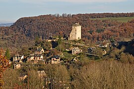 A general view of Muret-le-Château | |
show Location of Muret-le-Château | |
 Muret-le-Château | |
| Coordinates: 44°29′40″N 2°34′25″E / 44.494415°N 2.573711°ECoordinates: 44°29′40″N 2°34′25″E / 44.494415°N 2.573711°E | |
| Country | France |
| Region | Occitanie |
| Department | Aveyron |
| Arrondissement | Rodez |
| Canton | Vallon |
| Government | |
| • Mayor (2020–2026) | Roland Aygalenq |
| Area 1 | 14.98 km2 (5.78 sq mi) |
| Population (Jan. 2018)[1] | 357 |
| • Density | 24/km2 (62/sq mi) |
| Time zone | UTC+01:00 (CET) |
| • Summer (DST) | UTC+02:00 (CEST) |
| INSEE/Postal code | 12165 /12330 |
| Elevation | 327–604 m (1,073–1,982 ft) |
| 1 French Land Register data, which excludes lakes, ponds, glaciers > 1 km2 (0.386 sq mi or 247 acres) and river estuaries. | |


Muret-le-Château (French: [myʁɛ l(ə) ʃɑto]; Occitan: Muret) is a commune in the Aveyron department in southern France.
Population[]
| Year | Pop. | ±% |
|---|---|---|
| 1962 | 294 | — |
| 1968 | 260 | −11.6% |
| 1975 | 207 | −20.4% |
| 1982 | 208 | +0.5% |
| 1990 | 263 | +26.4% |
| 1999 | 272 | +3.4% |
| 2008 | 316 | +16.2% |
See also[]
References[]
- ^ "Populations légales 2018". INSEE. 28 December 2020.
| Wikimedia Commons has media related to Muret-le-Château. |
This Aveyron geographical article is a stub. You can help Wikipedia by . |
Categories:
- Communes of Aveyron
- Aveyron geography stubs