Sainte-Croix, Aveyron
show This article may be expanded with text translated from the corresponding article in French. (December 2008) Click [show] for important translation instructions. |
Sainte-Croix | |
|---|---|
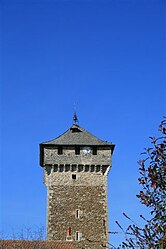 Clock tower | |
show Location of Sainte-Croix | |
 Sainte-Croix | |
| Coordinates: 44°25′38″N 1°58′05″E / 44.4272°N 1.9681°ECoordinates: 44°25′38″N 1°58′05″E / 44.4272°N 1.9681°E | |
| Country | France |
| Region | Occitanie |
| Department | Aveyron |
| Arrondissement | Villefranche-de-Rouergue |
| Canton | Villeneuvois et Villefranchois |
| Government | |
| • Mayor (2008–2014) | Raymond Bonestèbe |
| Area 1 | 25.88 km2 (9.99 sq mi) |
| Population (Jan. 2018)[1] | 743 |
| • Density | 29/km2 (74/sq mi) |
| Time zone | UTC+01:00 (CET) |
| • Summer (DST) | UTC+02:00 (CEST) |
| INSEE/Postal code | 12217 /12260 |
| Elevation | 312–441 m (1,024–1,447 ft) (avg. 400 m or 1,300 ft) |
| 1 French Land Register data, which excludes lakes, ponds, glaciers > 1 km2 (0.386 sq mi or 247 acres) and river estuaries. | |


Sainte-Croix (Languedocien: Santa Crotz) is a commune in the Aveyron department in southern France.
Population[]
| Year | Pop. | ±% |
|---|---|---|
| 1962 | 481 | — |
| 1968 | 539 | +12.1% |
| 1975 | 541 | +0.4% |
| 1982 | 601 | +11.1% |
| 1990 | 608 | +1.2% |
| 1999 | 632 | +3.9% |
| 2008 | 719 | +13.8% |
See also[]
References[]
- ^ "Populations légales 2018". INSEE. 28 December 2020.
| Wikimedia Commons has media related to Sainte-Croix (Aveyron). |
This Aveyron geographical article is a stub. You can help Wikipedia by . |
Categories:
- Communes of Aveyron
- Aveyron geography stubs