Chéry
Chéry | |
|---|---|
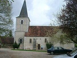 The church in Chéry | |
show Location of Chéry | |
 Chéry | |
| Coordinates: 47°07′15″N 2°02′50″E / 47.1208°N 2.0472°ECoordinates: 47°07′15″N 2°02′50″E / 47.1208°N 2.0472°E | |
| Country | France |
| Region | Centre-Val de Loire |
| Department | Cher |
| Arrondissement | Vierzon |
| Canton | Mehun-sur-Yèvre |
| Intercommunality | CC Cœur de Berry |
| Government | |
| • Mayor (2008–2014) | Irène Chauveau |
| Area 1 | 13.54 km2 (5.23 sq mi) |
| Population (Jan. 2018)[1] | 217 |
| • Density | 16/km2 (42/sq mi) |
| Time zone | UTC+01:00 (CET) |
| • Summer (DST) | UTC+02:00 (CEST) |
| INSEE/Postal code | 18064 /18120 |
| Elevation | 104–161 m (341–528 ft) (avg. 100 m or 330 ft) |
| 1 French Land Register data, which excludes lakes, ponds, glaciers > 1 km2 (0.386 sq mi or 247 acres) and river estuaries. | |


Chéry is a commune in the Cher department in the Centre-Val de Loire region of France.
Geography[]
An area of farming and forestry, comprising the main village and a hamlet, situated in the valley of the river Arnon some 8 miles (13 km) south of Vierzon, at the junction of the D75, D165 and the D68 roads.
Population[]
| Year | Pop. | ±% |
|---|---|---|
| 1962 | 299 | — |
| 1968 | 306 | +2.3% |
| 1975 | 276 | −9.8% |
| 1982 | 266 | −3.6% |
| 1990 | 268 | +0.8% |
| 1999 | 236 | −11.9% |
| 2008 | 219 | −7.2% |
Sights[]
- The church of St. Didier, dating from the sixteenth century.
See also[]
- Communes of the Cher department
References[]
- ^ "Populations légales 2018". INSEE. 28 December 2020.
| Wikimedia Commons has media related to Chéry. |
| show Communes of the Cher department |
|---|
| show Authority control |
|---|
Categories:
- Communes of Cher (department)