Poisieux
Poisieux | |
|---|---|
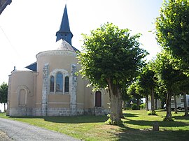 The church in Poisieux | |
show Location of Poisieux | |
 Poisieux | |
| Coordinates: 47°01′48″N 2°05′56″E / 47.03°N 2.0989°ECoordinates: 47°01′48″N 2°05′56″E / 47.03°N 2.0989°E | |
| Country | France |
| Region | Centre-Val de Loire |
| Department | Cher |
| Arrondissement | Bourges |
| Canton | Chârost |
| Intercommunality | CC Cœur de Berry |
| Government | |
| • Mayor (2020–2026) | Filipe Maia |
| Area 1 | 10.3 km2 (4.0 sq mi) |
| Population (Jan. 2018)[1] | 220 |
| • Density | 21/km2 (55/sq mi) |
| Time zone | UTC+01:00 (CET) |
| • Summer (DST) | UTC+02:00 (CEST) |
| INSEE/Postal code | 18182 /18290 |
| Elevation | 113–152 m (371–499 ft) (avg. 145 m or 476 ft) |
| 1 French Land Register data, which excludes lakes, ponds, glaciers > 1 km2 (0.386 sq mi or 247 acres) and river estuaries. | |


Poisieux (French pronunciation: [pwazjø]) is a commune in the Cher department in the Centre-Val de Loire region of France.
It is a small farming village situated by the banks of the river Arnon. It borders with the department of Indre, some 14 miles (23 km) southwest of Bourges, at the junction of the D190 and the D18 roads.
Population[]
| Year | Pop. | ±% |
|---|---|---|
| 1962 | 180 | — |
| 1968 | 212 | +17.8% |
| 1975 | 210 | −0.9% |
| 1982 | 167 | −20.5% |
| 1990 | 155 | −7.2% |
| 1999 | 158 | +1.9% |
| 2008 | 209 | +32.3% |
Sights[]
- The church, dating from the nineteenth century.
- The chateau of Mazières.
See also[]
- Communes of the Cher department
References[]
- ^ "Populations légales 2018". INSEE. 28 December 2020.
| Wikimedia Commons has media related to Poisieux. |
| show Communes of the Cher department |
|---|
Categories:
- Communes of Cher (department)