Chambon, Cher
Chambon | |
|---|---|
 The church of Saint-Pierre, in Chambon | |
show Location of Chambon | |
 Chambon | |
| Coordinates: 46°47′16″N 2°19′32″E / 46.7878°N 2.3256°ECoordinates: 46°47′16″N 2°19′32″E / 46.7878°N 2.3256°E | |
| Country | France |
| Region | Centre-Val de Loire |
| Department | Cher |
| Arrondissement | Saint-Amand-Montrond |
| Canton | Trouy |
| Intercommunality | CC Arnon Boischaut Cher |
| Government | |
| • Mayor (2008–2014) | Gérard Lucas |
| Area 1 | 13.91 km2 (5.37 sq mi) |
| Population (Jan. 2018)[1] | 171 |
| • Density | 12/km2 (32/sq mi) |
| Time zone | UTC+01:00 (CET) |
| • Summer (DST) | UTC+02:00 (CEST) |
| INSEE/Postal code | 18046 /18190 |
| Elevation | 147–187 m (482–614 ft) (avg. 170 m or 560 ft) |
| 1 French Land Register data, which excludes lakes, ponds, glaciers > 1 km2 (0.386 sq mi or 247 acres) and river estuaries. | |


Chambon is a commune in the Cher department in the Centre-Val de Loire region of France.
Geography[]
The town was a part of the canton of Châteauneuf-sur-Cher; in 2015, following the redistribution of the cantons of the department, it became a part of the canton of Trouy.[2]
Location[]

Typology[]
Chambon is a rural commune.[3] It is a part of the municipalities with little or very little density, within the meaning of the municipal density grid of INSEE.[4][5]
In addition, the municipality is part of the attraction area of Saint-Amand-Montrond, of which it is a municipality in the crown. This area, which includes 36 municipalities, is categorized into areas with fewer than 50,000 inhabitants.[6][7]
Land use[]
The zoning of the municipality, as reflected in the database European occupation biophysical soil Corine Land Cover (CLC), is marked by the importance of the agricultural land (89.5% in 2018), a proportion roughly equivalent to that of 1990 (89.4%). The detailed breakdown in 2018 is as follows:[8]
- grasslands (46.4%)
- arable land (43.1%)
- forests (10.5%)
Politics and administration[]
| Period | Name | |
|---|---|---|
| The missing data must be completed. | ||
| March 2001 | March 2008 | Louis Legrand |
| March 2008 | January 2010 | Gerard Lucas |
| February 2010 | 2014 | Jean-Marie Brochard |
| April 2014 | In progress | Maryse Jacquin-Salomon[10] |
Environmental policy[]
In its 2016 winners, the National Council of Flowered Cities and Villages of France awarded one flower to the municipality in Concours des villes et villages fleuris.[11]
Population[]
| Year | Pop. | ±% |
|---|---|---|
| 1962 | 215 | — |
| 1968 | 231 | +7.4% |
| 1975 | 195 | −15.6% |
| 1982 | 143 | −26.7% |
| 1990 | 122 | −14.7% |
| 1999 | 134 | +9.8% |
| 2008 | 148 | +10.4% |
Sights[]
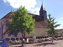
The Church of Saint-Pierre de Chambon has been listed as a historical monument since 1922.[12]
See also[]
- Communes of the Cher department
References[]
- ^ "Populations légales 2018". INSEE. 28 December 2020.
- ^ "Décret n° 2014-206 du 21 février 2014 portant délimitation des cantons dans le département du Cher". www.legifrance.gouv.fr. Retrieved 2021-07-25.
- ^ "Zonage rural | L'Observatoire des Territoires". www.observatoire-des-territoires.gouv.fr. Retrieved 2021-07-25.
- ^ "Définition - Commune urbaine | Insee". www.insee.fr. Retrieved 2021-07-25.
- ^ "Comprendre la grille de densité | L'Observatoire des Territoires". www.observatoire-des-territoires.gouv.fr. Retrieved 2021-07-25.
- ^ "Base des aires d'attraction des villes 2020 | Insee". www.insee.fr. Retrieved 2021-07-25.
- ^ "En France, neuf personnes sur dix vivent dans l'aire d'attraction d'une ville - Insee Focus - 211". www.insee.fr. Retrieved 2021-07-25.
- ^ "CORINE Land Cover | Données et études statistiques". archive.wikiwix.com. Retrieved 2021-07-25.
- ^ "Chambon - Mairie de Chambon et sa commune (18190) (Cher)". Annuaire-Mairie (in French). Retrieved 2021-07-25.
- ^ "Résultats élections municipales 2020 : Chambon | Le Télégramme". elections.letelegramme.fr. Retrieved 2021-07-25.
- ^ "Labeled municipalities". villes-et-villages-fleuris.
- ^ "Eglise Saint-Pierre". www.pop.culture.gouv.fr. Retrieved 2021-07-25.
| Wikimedia Commons has media related to Chambon (Cher). |
| show Communes of the Cher department |
|---|
- Communes of Cher (department)