Limeux, Cher
Limeux | |
|---|---|
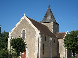 The church in Limeux | |
show Location of Limeux | |
 Limeux | |
| Coordinates: 47°04′32″N 2°06′34″E / 47.0756°N 2.1094°ECoordinates: 47°04′32″N 2°06′34″E / 47.0756°N 2.1094°E | |
| Country | France |
| Region | Centre-Val de Loire |
| Department | Cher |
| Arrondissement | Vierzon |
| Canton | Mehun-sur-Yèvre |
| Intercommunality | CC Cœur de Berry |
| Government | |
| • Mayor (2008–2014) | Monique Convergne |
| Area 1 | 13.17 km2 (5.08 sq mi) |
| Population (Jan. 2018)[1] | 163 |
| • Density | 12/km2 (32/sq mi) |
| Time zone | UTC+01:00 (CET) |
| • Summer (DST) | UTC+02:00 (CEST) |
| INSEE/Postal code | 18128 /18120 |
| Elevation | 127–149 m (417–489 ft) (avg. 140 m or 460 ft) |
| 1 French Land Register data, which excludes lakes, ponds, glaciers > 1 km2 (0.386 sq mi or 247 acres) and river estuaries. | |


Limeux is a commune in the Cher department in the Centre-Val de Loire region of France.
Geography[]
A farming area comprising the village and a couple of hamlets, situated between the valleys of the rivers Cher and Arnon some 12 miles (19 km) south of Vierzon at the junction of the D23 and the D123 roads.
Population[]
| Year | Pop. | ±% |
|---|---|---|
| 1962 | 157 | — |
| 1968 | 163 | +3.8% |
| 1975 | 144 | −11.7% |
| 1982 | 133 | −7.6% |
| 1990 | 158 | +18.8% |
| 1999 | 145 | −8.2% |
| 2008 | 149 | +2.8% |
Sights[]
- The church of St. Martin, dating from the eleventh century.
- The castle of Saragosse, built in the fourteenth century.
- The thirteenth-century chapel of the old priory of Saint-Laurent de Manzay.
See also[]
- Communes of the Cher department
References[]
- ^ "Populations légales 2018". INSEE. 28 December 2020.
| Wikimedia Commons has media related to Limeux (Cher). |
| show Communes of the Cher department |
|---|
Categories:
- Communes of Cher (department)